
Weather Systems and Severe Weather
9.5 Hurricanes
Tropical cyclones are considered some of the most powerful weather systems on the planet because of their size, strength, and potential loss to life and property. Tropical cyclones go by different names depending on their geographic location. In North and Central America, they are called hurricanes. In the northwestern portion of the Pacific Ocean near China and Japan, they are called typhoons. Furthermore, in the Indian Ocean and Australia, they are named cyclones. They all have winds exceeding 74 mph, can be hundreds of miles wide, and tower over 40,000 feet above sea level. (Dastrup, 2014)
Anatomy of a Hurricane
The anatomy of a hurricane is relatively simple, though the processes involved are quite complex. As a low-pressure disturbance forms, the warm, moist air rushes towards the low pressure to rise upward to form towering thunderstorms. Around the low pressure, disturbance in a wall of clouds called an eyewall. Within the eyewall, the wind speeds are highest, the clouds are the tallest, atmospheric pressure is at its lowest, and precipitation is most intense.
At the center or heart of the hurricane is called the eye. Within the eye of a hurricane, winds are light, precipitation is minimal, and the skies above are occasionally clear. It is the calm region of the tropical storm, but that is what makes it so dangerous. Many people tend to go outside as the eye moves overhead because they believe the storm is over. However, what some do not realize is that “round two” is coming from behind. Moving away from the eyewall are organized, intense thunderstorms, called spiral rain bands, that rotate around and toward the storm’s eyewall. (Dastrup, 2014)

Development of a Hurricane
There are several requirements needed for a hurricane to form. First, hurricanes must form over warm, moist oceans with surface temperatures that are at least 80 degrees Fahrenheit for at least 150 feet deep. This allows for water to evaporate, causing the air to become warm and humid. The atmosphere must also be warm and humid so that latent heat energy could be released as the moisture condenses within a hurricane. The third ingredient is a low-pressure disturbance, called an easterly wave or tropical wave, which is needed for air to converge toward and ascend to produce powerful thunderstorms.
Once these storms form, most need to be 5-20 degrees north or south of the equator to develop into a hurricane. If the tropical storm forms between 0-5 degrees north or south, the Coriolis effect is not strong enough to cause the storm to organize into a system and rotate. If the storm forms too far north or south, the water is too cold to develop into a hurricane. Finally, in order for a hurricane to form in the Atlantic Ocean, there must be little to no wind shear. If the jet stream is too low and blowing eastward while the trade winds are blowing west-ward, the wind shear will tear apart the forming cyclone before it can strengthen into a hurricane. Most hurricanes form under large regions of high pressure within the Atlantic Ocean. Recall that high pressure tends to have clear skies and mild winds.
Now there are five primary stages a hurricane goes through. The first stage goes back to the low-pressure disturbance or easterly wave. Where easterly waves develop is currently being debated. However, it is believed that they form either off the west coast of Africa near the Canary Islands or eastern Africa near Ethiopia. At this stage, warm, moist air begins to rise within the low-pressure disturbance releasing vast amounts of latent heat because of condensation, causing the storm to intensify. If the easterly waveforms under the right conditions, the Coriolis effect may allow the thunderstorms to organize and rotate, and it becomes a tropical depression. If the tropical storm continues to organize and strengthen with sustained winds between 39-73 mph, the storm is upgraded to a tropical storm and given a name by the National Hurricane Center. If intense rotation continues, the storm grows with winds reaching 74 mph or higher, it becomes a hurricane.
There are a variety of reasons why a hurricane will begin to die off. First, it could move in-to colder water, which does not supply the storm with as much latent heat energy. The idea is that colder water can not evaporate as easily, so no latent heat is released. Another way is if the storm moves over the land, causing it to lose its moisture source below. Finally, a third way a tropical storm could die-off is to move into an area where winds aloft begin to tear the storm apart.

An atmospheric event that can limit hurricane development occurs in the Pacific Ocean called El Nino. During an El Nino, the jet stream over the eastern United States migrates into lower latitudes. This upper wind shear caused by the jet stream moving eastward and the trade winds moving westward tends to tear apart hurricanes before they can form.
Another phenomenon that can deduce or eliminate hurricane development is dust storms coming off the coast of the Sahara Desert and into the Atlantic Ocean. In the summer of 2006, following the record activity of 2005 with Hurricane Katrina, the Sahara Desert in Africa had several sandstorms coming off into the Atlantic Ocean. Now recall two things: hurricanes originate near Africa, and the Atlantic Ocean must be over 80 degrees Fahrenheit for them to form. It is believed that the sandstorms blocked the sun over the eastern Atlan-tic, which ultimately cooled the ocean enough to hinder hurricane genesis. (Dastrup, 2014)
Hurricane Classification and Naming
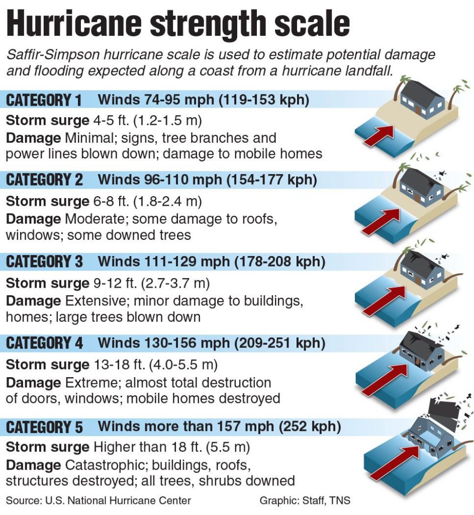
The Saffir-Simpson Scale was created to determine the strength and intensity of hurricanes. Just like the Fujita scale, it ranges from 1-5, with category five being the strongest. The intensity of a hurricane increases as the atmospheric pressure near the eye decreases and the pressure-gradient force becomes steeper (atmospheric pressure decreases rapidly towards the eye), causing the winds to intensify, resulting in the potential for more damage. (Dastrup, 2014)
For many years, hurricanes were named based on where they struck land. For example, the Galveston Hurricane hit Galveston, Texas in 1900. In the early 1900s, scientists started naming hurricanes using female names; clearly a sexist action by mostly white, male scientists at the time. But by the 1950s, the National Hurricane Center started naming hurricanes alphabetically, starting with the letter A, and based on male and female names. If the first year started the letter A with a female name, the following year, the first name would be male. The names are also determined six years in advance so that politics do not get involved with the naming of these deadly storms.
Hazards
Storm Surge
Storm surges, defined as rising ocean levels along a coastal area because of low atmospheric pressure within a tropical cyclone, are the most dangerous hazard created by a tropical cyclone. They are blamed for 90 percent of all deaths and property damage. The height of a storm surge is dependent on the strength of winds, which is dependent on the low pressure near the eye. The low pressure does not “pull up” ocean water to create a storm surge; instead, the wind blowing towards the low pressure causes the water underneath to pile up near the hurricane’s eye.
As it approaches the shore, the piling causes the sea level to rise and flood the area near the eye and eyewall. Storm surges are most damaging when the atmospheric pressure decrease, if the continental shelf rises slowly as it approaches the shore, or if the storm surge arrives during high tide. The storm surge is also highest on the right side of the eye as winds blow to-ward shore in a counter-clockwise rotation. New Orleans was struck on the left side of the storm surge, so they did not receive the highest portion of the surge. (Dastrup, 2014)
Wind Damage and Inland Flooding
Another hazard created by hurricanes is property damage caused by hurricane-force winds. Though property, such as mobile homes, is obvious, tall buildings are also susceptible to wind damage. People in tall buildings should get below the tenth floor because of powerful winds but should stay above the main floor in case of flooding. Hurricanes also produce tornadoes. It is believed that hurricanes Charley, Frances, Gaston, and Ivan that struck Florida in 2004 produced nearly 300 tornadoes!
Flooding, besides storm surges, is also a dangerous component of hurricanes. The 2004 hurricane season killed over 3,000. The majority of the deaths occurred in Haiti from flash floods and mudslides caused by heavy precipitation. Category 5 Hurricane Mitch in 1998 killed over 18,000 people, most in Central America, dropping nearly three feet of rain, causing massive flooding and mudslides.
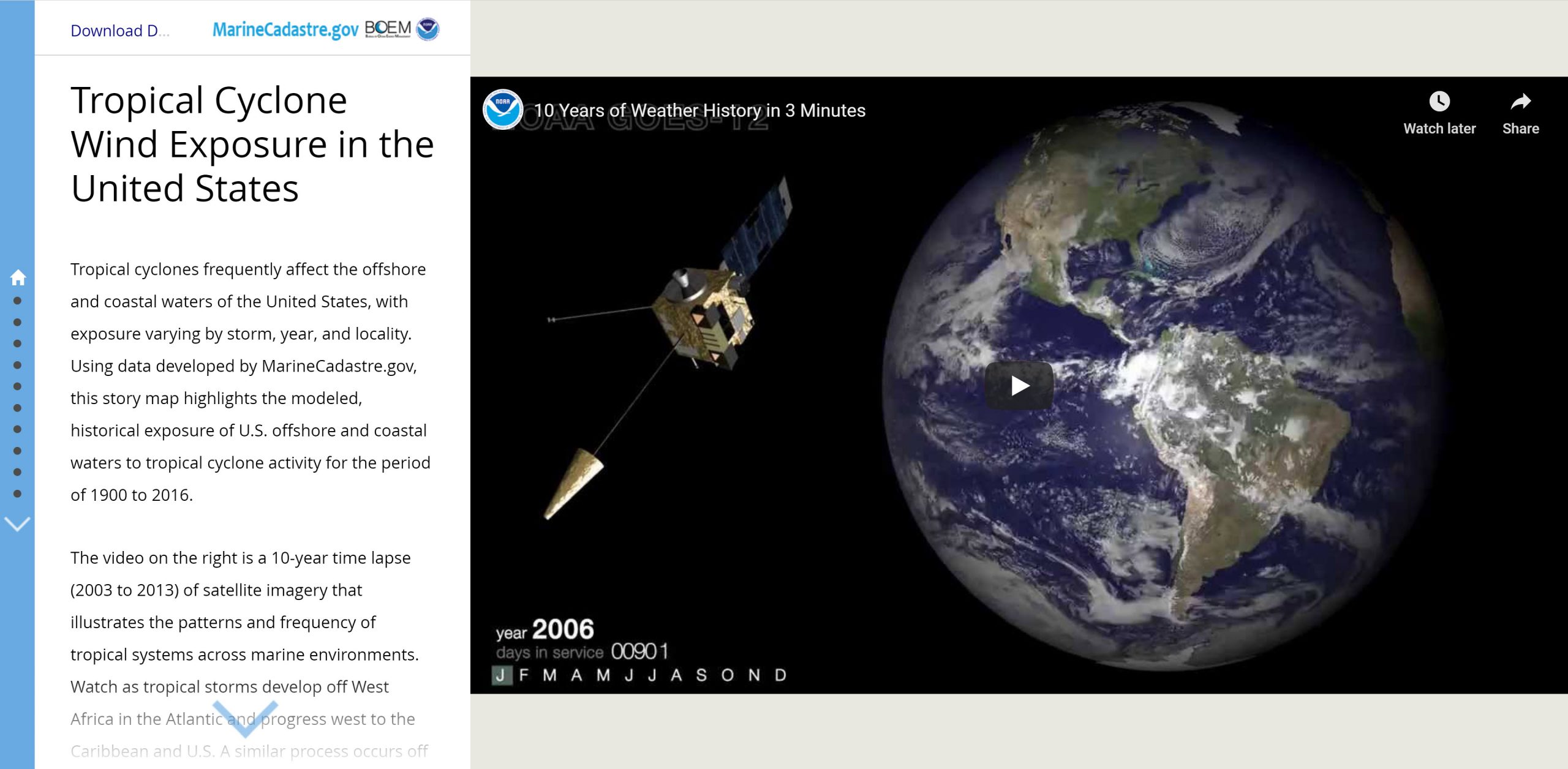
Click on the story map below to learn more about tropical cyclones in the United States.
Hurricane Forecasting
The governmental agency that analyzes and monitors hurricanes is NOAA’s National Hurricane Center. Most hurricanes move westward as they approach North and Central America, then veer northeast. The reason is relatively simple. At around 30 degrees north, there is a sub-tropical high called the Bermuda High. As tropical storm systems move across the Atlantic Ocean, they are pushed westward from the underside of the subtropical high’s clockwise rotation (a.k.a. the trade winds). As tropical storms move northward, the subtropical high’s clockwise rotation (a.k.a. the westerly winds) pushes the storms northwestward into colder water. (Dastrup, 2014)
Click here to read about how the National Oceanic and Atmospheric Administration (NOAA) prepares for hurricanes season.
