
Planet Earth
3.6 Theory of Plate Tectonics
Continental Drift Hypothesis
Alfred Wegener (1880-1930) was a German scientist specializing in meteorology and climatology. He had a knack for questioning accepted ideas. This started in 1910 when he disagreed with isostasy (vertical land movement due to the weight being removed or added) as the explanation for the Bering Land Bridge. After literary reviews, he published a hypothesis stating the continents had moved in the past. While he did not have the precise mechanism, he had an extensive list of evidence that backed up his continental drift hypothesis.
Early Evidence for Continental Drift
The first piece of evidence is that the shape of the coastlines of some continents fit together like pieces of a jigsaw puzzle. Since the first world map, people have noticed the similarities in the coastlines of South America and Africa, and the continents being ripped apart has even been mentioned as an explanation. Antonio Snider-Pellegrini did preliminary work on continental separation and matching fossils in 1858.
Wegener did differently than others by synthesizing a significant amount of data in one place and using the continental shelf’s shape, the continent’s actual edge, instead of the current coastline, which fit even better than previous efforts. Wegener also compiled and added evidence of similar rocks, fossils, and glacial formations across the oceans.
Fossil Evidence
For example, the primitive aquatic reptile Mesosaurus was found on the separate coastlines of the continents of Africa and South America, and the reptile Lystrosaurus was found in Africa, India, and Antarctica. These were land-dwelling creatures that could not swim across an entire ocean; thus, opponents of continental drift explained away this by land bridges. In addition, the land bridges had eroded, allowing animals and plants to move between the continents. However, some of the presumed land bridges must have stretched across broad, deep oceans.

Geologic Evidence
Mountain ranges with the same rock types, structures, and ages are now on opposite sides of the Atlantic Ocean. For example, the Appalachians of the eastern United States and Canada are like mountain ranges in east Greenland, Ireland, Great Britain, and Norway. Wegener concluded that they formed a single mountain range separated as the continents drifted. (Dastrup, 2014)
Climatic Evidence
Another significant piece of evidence was climate anomalies. Late Paleozoic glacial evidence was found in widespread, warm areas like southern Africa, India, Australia, and the Arabian subcontinent. Wegener himself had found evidence of tropical plant fossils in areas north of the Arctic Circle. According to Wegener, the more straightforward explanation that fits all the climate, rock, and fossil observations, mainly as more data were collected, involved moving continents.
Grooves and rock deposits left by ancient glaciers are found today on different continents near the equator. This would indicate that the glaciers formed in the middle of the ocean or covered most of the Earth. Today, glaciers only form on land and nearer the poles. Wegener thought the glaciers were centered over the southern landmass close to the South Pole, and the continents later moved to their present positions.
Proposed Mechanism for Continental Drift
Wegener’s work was considered a fringe theory for his entire life. One of the most significant flaws and easiest dismissals of Wegener’s hypothesis was a mechanism for the movement of the continents. The continents did not appear to move, and extraordinary evidence would need to be provided to change the establishment’s minds, including a mechanism for movement. Other pro-continental drift followers had used expansion, contraction, or even the origin of the Moon as ideas for how the continents moved. Wegener used centrifugal forces and precession to explain the movement, but that was proven wrong. In addition, he speculated about seafloor spreading, with hints of convection within the Earth, unsubstantiated. As it turns out, convection within the mantle has been revealed as a significant force in driving plate movements, according to current knowledge.
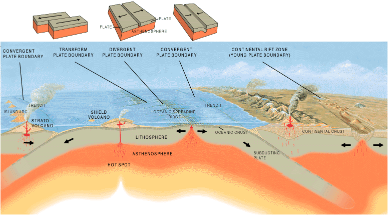
Theory of Plate Tectonics
Wegener died in 1930 on an expedition in Greenland. He was poorly respected in his lifetime, and his ideas of moving continents seemed destined to be lost to history as a fringe idea. However, in the 1950s, evidence began to trickle in, making continental drift more viable. By the 1960s, enough evidence supported Wegener’s missing mechanism, seafloor spreading, allowing continental drift’s hypothesis to develop into the Theory of Plate Tectonics. Widespread acceptance among scientists has transformed Wegener’s hypothesis into a Theory. Today, GPS and earthquake data continue to back up the theory. Below are the pieces of evidence that allowed the transformation.

Mapping the Ocean Floors
Starting in 1947 and using an adaptation of sonar, researchers began to map a poorly understood topographic and thermal high in the mid-Atlantic. Bruce Heezen and Marie Tharp were the first to make a detailed map of the ocean floor, and this map revealed the mid-Atlantic Ridge, a basaltic feature unlike the continents. Initially, this was considered part of an expanding Earth or a mechanism for the ocean’s growth. Transform faults were also added to explain movements more completely. However, when it was later realized that earthquake epicenters were also found within this feature, the idea that this was part of the continental movement took hold.
Another way the seafloor was mapped was magnetical. Scientists have long known strange magnetic anomalies (magnetic values that differ from expected values) associated with the ocean floor. This tool was adapted by geologists later for further study of the ocean depths, including strange alternating symmetrical stripes on both sides of a feature (which would be discovered later as the mid-ocean Ridge) showing reversing magnetic pole directions. By 1963, these magnetic stripes would be explained concordantly with Hess’s spreading model and others.
Seafloor sediment was also an important feature measured in the oceans, including dredging and drilling. Sediment was believed to have been piling up on ocean floors in a static accumulation model for a long time. Initial studies showed less sediment than expected, and initial results were even used to argue against the continental movement. In addition, researchers discovered thinner sediment close to ridges with more time, indicating a younger age.
Wadati-Benioff Zones
Around the same time that mid-ocean ridges were being investigated, ocean trenches and island arcs were also linked to seismic action, explaining the opposite sides of the plates. A zone of deep earthquakes that lay along a plane trending from the surface near the trenches to inside the Earth beneath the continents and island arcs was recognized independently by several scientists. Today, called the Wadati-Benioff zone, it was an essential puzzle piece.
Paleomagnetism
Magnetic field mapping, as mentioned above, was not the only way magnetism was used in the development of plate tectonics. The first new hard evidence that supported plate motion came from paleomagnetism. Paleomagnetism studies magnetic fields frozen within rocks, basically a fossil compass. This is typically most useful with igneous rocks where magnetic minerals like magnetite crystallizing in the magma align with the Earth’s magnetic field and in the solid rock point to the paleo-magnetic north. The Earth’s magnetic field creates flux lines surrounding the magnetic north and south poles (like a bar magnet), close to the Earth’s rotational north and south poles. In igneous rocks, magnetic minerals align parallel with these flux lines. Thus, magnetic inclination, related to latitude, and declination, related to magnetic north, are preserved in the rocks.
Scientists had noticed that, for some time, the magnetic north, to which many rocks pointed, was nowhere close to the current magnetic north. This was explained by implying that the magnetic north pole moved over time. Eventually, scientists realized that moving continents explained the data better than moving the pole alone.

Seafloor Spreading
World War II gave scientists the tools to find the mechanism for continental drift that had eluded Wegener. Maps and other data gathered during the war allowed scientists to develop the seafloor spreading hypothesis. This hypothesis traces oceanic crust from its origin at a mid-ocean ridge to its destruction at a deep-sea trench and is the mechanism for continental drift. (Seafloor Spreading | Earth Science, n.d.)
During World War II, battleships and submarines carried echo sounders to locate enemy submarines. Echo sounders produce sound waves that travel outward in all directions, bounce off the nearest object, and return to the ship. By knowing the sound speed in seawater, scientists calculate the distance to the object based on the time it takes for the wave to make a round trip. Most of the sound waves ricocheted off the ocean bottom during the war. This animation shows how sound waves create the seafloor and ocean crust pictures.
After the war, scientists pieced together the ocean depths to produce bathymetric maps, which revealed the ocean floor features as if the water were taken away. Even scientists were amazed that the seafloor was not completely flat. What was discovered was a large chain of mountains along the deep seafloor called mid-ocean ridges. Scientists also discovered deep-sea trenches along the edges of continents or in the sea near active volcanic chains. Finally, we found significant, flat areas called abyssal plains. When they first observed these bathymetric maps, scientists wondered what had formed these features.
Scientists combined these observations in the early 1960s to create the seafloor spreading hypothesis. In this hypothesis, a hot, buoyant mantle creates a mid-ocean ridge, causing the Ridge to rise upward. The hot magma at the Ridge erupts as lava that forms new seafloor. When the lava cools, the magnetite crystals take on the current magnetic polarity, and as more lava erupts, it pushes the seafloor horizontally away from the ridge axis. (Seafloor Spreading | Earth Science, n.d.)
The magnetic stripes continue across the seafloor. As oceanic crust forms and spreads, moving away from the ridge crest pushes the continent away from the ridge axis. If the oceanic crust reaches a deep-sea trench, it sinks into the trench and is lost into the mantle. Scientists know that the oldest crust is coldest and lies most profound in the ocean because it is less buoyant than the hot new crust.
Unifying Theory of Plate Tectonics
Using all the evidence mentioned, the theory of plate tectonics took shape. In 1966, J. Tuzo Wilson was the first scientist to put the entire picture of an ocean opening and closing. Before long, models were proposed showing the plates moving concerning each other with clear boundaries between them, and scientists had also started to piece together complicated tectonic histories. The plate tectonic revolution had taken hold.
Seafloor and continents move around on Earth’s surface, but what is moving? What part of the Earth makes up the “plates” in plate tectonics? This question was also answered because of the technology developed during the Cold War. The tectonic plates are made up of the lithosphere. Scientists set up seismograph networks during the 1950s and early 1960s to see if enemy nations tested atomic bombs. These seismographs also recorded all the earthquakes around the planet. The seismic records could be used to locate an earthquake’s epicenter, the point on Earth’s surface directly above the earthquake’s place. Earthquake epicenters outline these tectonic plates. Mid-ocean ridges, trenches, and significant faults mark the edges of these plates, along with where earthquakes occur. (Reading: Theory of Plate Tectonics | Geology (Modification for Lehman College, CUNY), n.d.)
The lithosphere is divided into a dozen central and several minor tectonic plates. The edges of the plates can be drawn by connecting the dots of the earthquakes’ epicenters. A single tectonic plate can be made of all oceanic lithosphere or all continental lithosphere, but nearly all tectonic plates are made of a combination of both. The movement of the plates over the Earth’s surface is termed plate tectonics. Plates move a few centimeters yearly at about the same rate as fingernails grow. (Theory of Plate Tectonics | Earth Science, n.d.)
