
Oceans and Coastal Environments
7.4 Topography and Landforms
Topology of the Sea Floor
Oceans cover 71 percent of Earth’s surface and hold 97 percent of Earth’s water. The ocean’s water is critical to plate tectonics, volcanism, and, of course, life on Earth. We know more about the surface of the Moon than the floor of the oceans. Whether this is true or not, the critical point is that the ocean floor is covered with an average of nearly 4,000 m of water, and it is pitch black below a few hundred meters, so it is not easy to discover what is down there. We know a lot more about the oceans than we used to, but there is still a great deal more to learn. (Earle, 2015)
Earth has had oceans for a very long time, dating back to the point where the surface had cooled enough to allow liquid water, only a few hundred million years after Earth’s formation. At that time, there were no continental rocks, so the water here was likely spread out over the surface in one giant (but relatively shallow) ocean. (Earle, 2019)
We examined the seafloor’s topography from the perspective of plate tectonics, but we will take another look at the essential features from an oceanographic perspective. The important features are the extensive continental shelves less than 250 m deep (pink); the vast deep abyssal plains between 4,000 and 6,000 m deep (light and dark blue); the mid-Atlantic ridge, in many areas shallower than 3,000 m; and the deep ocean trench north of Puerto Rico. (18.1 The Topography of the Sea Floor – Physical Geology, n.d.)

The main features of the Pacific Ocean floor are the continental slopes, which drop from about 200 m to several thousand meters over a distance of a few hundred kilometers; the abyssal plains – exceedingly flat and from 4,000 m to 6,000 m deep; volcanic seamounts and islands; and trenches at subduction zones that are up to 11,000 m deep.
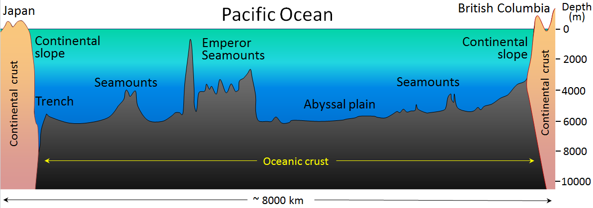
The ocean floor is entirely underlain by mafic oceanic crust, while the continental slopes are underlain by felsic continental crust (mostly granitic and sedimentary rocks). Moreover, the denser oceanic crust floats lower on the mantle than continental crust does, which is why oceans are oceans. Although the temperature of the ocean surface varies widely, from a few degrees on either side of freezing in polar regions to over 25°C in the tropics, in most parts of the ocean, the water temperature is around ten °C at 1,000 m depth and about four °C from 2,000 m depth to the bottom. (18.1 The Topography of the Sea Floor – Physical Geology, n.d.)
The deepest parts of the ocean are within the subduction trenches, and the deepest of these is the Marianas Trench in the southwestern Pacific (near Guam) at 11,000 m. Other trenches in the southwestern Pacific are over 10,000 m deep; the Japan Trench is over 9,000 m deep, and the Puerto Rico and Chile-Peru Trenches are over 8,000 m deep. Shallow trenches tend to be that way because they have significant sediment infill. There is no recognizable trench along the Juan de Fuca Plate subduction zone because it has been filled with sediments from the Fraser and Columbia Rivers. (Earle, 2015)
Landforms of Coastal Erosion
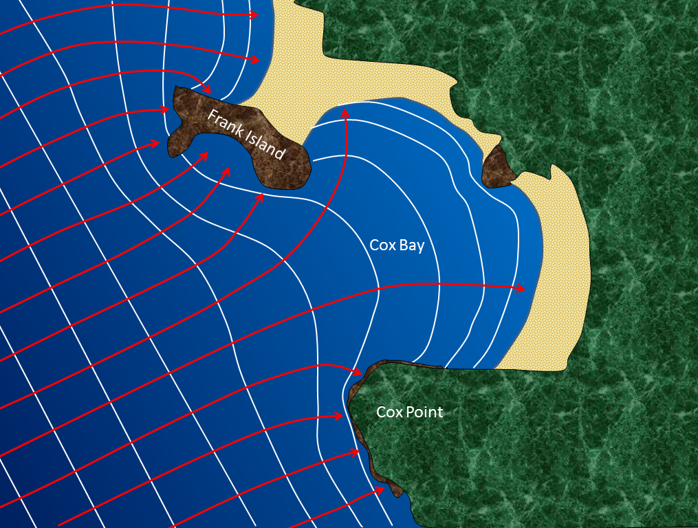
Large waves crashing onto a shore bring a tremendous amount of energy that has a significant eroding effect. Several unique erosion features commonly form on rocky shores with strong waves. When waves approach an irregular shore, they are slowed down to varying degrees, depending on differences in the water depth, and as they slow, they are bent or refracted. That energy is evenly spaced out in the deep water, but because of refraction, the waves’ energy, which moves perpendicular to the wave crests, is being focused on the headlands. On irregular coasts, the headlands receive much more wave energy than the intervening bays, and thus they are more strongly eroded. The result of this is coastal straightening. Like the west coast of Vancouver Island, an irregular coast will eventually become straightened, although that process will take millions of years.
Wave erosion is highest in the surf zone, where the wave base is impinging strongly on the seafloor and where the waves are breaking. The result is that the substrate in the surf zone is typically eroded to a flat surface known as a wave-cut platform or wave-cut terrace. A wave-cut platform extends across the intertidal zone. (3.3 Crystallization of Magma – Physical Geology – 2nd Edition, n.d.)
Resistant rock that does not get eroded entirely while forming a wave-cut platform will remain behind to form a stack. Here the different layers of the sedimentary rock have different resistance to erosion. The upper part of this stack is made up of rock that resisted erosion, and that rock has protected a small pedestal of underlying softer rock. The softer rock will eventually be eroded, and the big rock will become just another boulder on the beach.

Arches and sea caves are related to stacks because they all form because of the erosion of non-resistant rock. (17.2 Landforms of Coastal Erosion | Physical Geology, n.d.)

Submarine Canyons
Submarine canyons are narrow and deep canyons on continental shelves in the marine environment. They typically form at the mouths of sizeable landward river systems, both by cutting down into the continental shelf during low sea levels and by continual material slumping or flowing down from the mouth of the river or a delta. Underwater currents rich in sediment pass through the canyons, erode them, and drain onto the ocean floor. Steep delta faces and underwater flows of sediments are released down the continental slope as underwater landslides, called turbidity flows. The erosive action of this type of flow continues to cut the canyon, and eventually, fan-shaped deposits develop on the ocean floor beyond the continental slope.
Landforms of Coastal Deposition
Some coastal areas are dominated by erosion, an example being the Pacific coast of Canada and the United States. In contrast, others are dominated by deposition, examples being the Atlantic and Caribbean coasts of the United States. However, deposition and erosion are happening to varying degrees on almost all coasts, although in various places. On deposition-dominant coasts, the coastal sediments are still being eroded from some areas and deposited in others.
The main factor in determining if the coast is dominated by erosion or deposition is its history of tectonic activity. A coast like that of British Columbia is tectonically active, and compression and uplift have been going on for tens of millions of years. This coast has also been uplifted by isostatic rebound during the past 15,000 years due to deglaciation. On the other hand, the coasts of the United States along the Atlantic and the Gulf of Mexico have not seen significant tectonic activity in a few hundred million years. As a result, these areas have little topographic relief, and there is now minimal erosion of coastal bedrock. (17.3 Landforms of Coastal Deposition – Physical Geology, n.d.)
On coasts dominated by depositional processes, most of the deposited sediment typically comes from large rivers. An obvious example is where the Mississippi River flows into the Gulf of Mexico at New Orleans; another is the Fraser River in Vancouver. No large rivers bring sandy sediments to the west coast of Vancouver Island, but there are still long and wide sandy beaches there. In this area, most of the sand comes from glaciofluvial sand deposits situated along the shore behind the beach, and some come from the erosion of the rocks on the headlands.
On a sandy marine beach, the beach face is between the low and high tide levels. A berm is a flatter region beyond the reach of high tides; this area stays dry except during large storms.
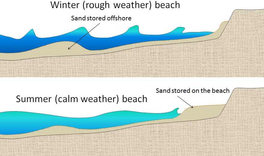
Most beaches go through a seasonal cycle because conditions change from summer to winter. In summer, sea conditions are calm with long-wavelength, low-amplitude waves generated by distant winds. Winter conditions are rougher, with shorter-wavelength, higher-amplitude waves caused by strong local winds. The heavy seas of winter gradually erode sand from beaches, moving it to an underwater sandbar offshore. The gentler summer waves slowly push this sand back toward the shore, creating a broader and flatter coast.
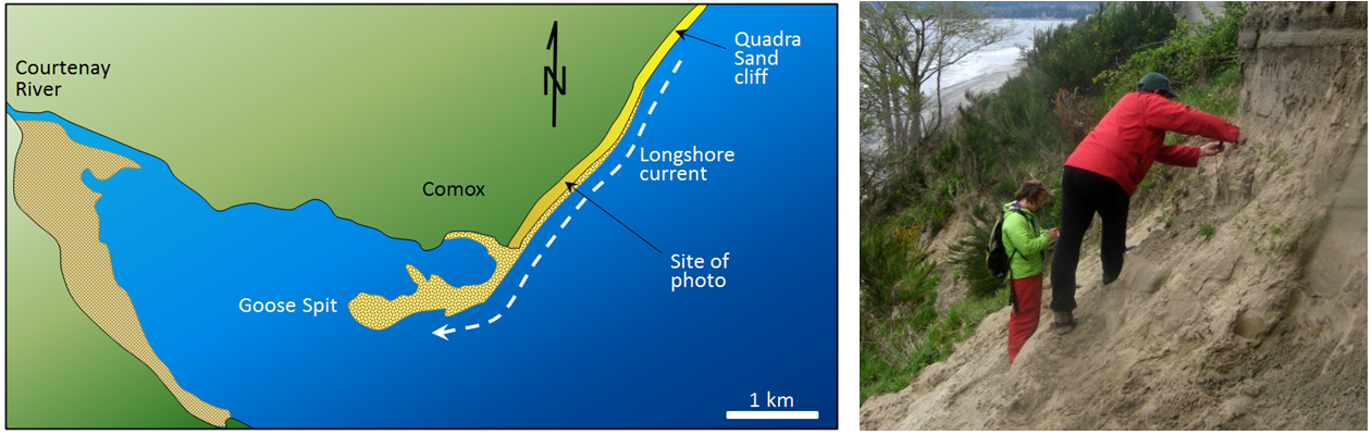
The evolution of sandy depositional features on seacoasts is primarily influenced by waves and currents, especially longshore currents. As sediment is transported along a shore, it is either deposited on beaches or creates other depositional features. For example, a spit is an elongated sandy deposit that extends out into open water in the direction of a longshore current. (3.4 Classification of Igneous Rock – Physical Geology – 2nd Edition, n.d.)
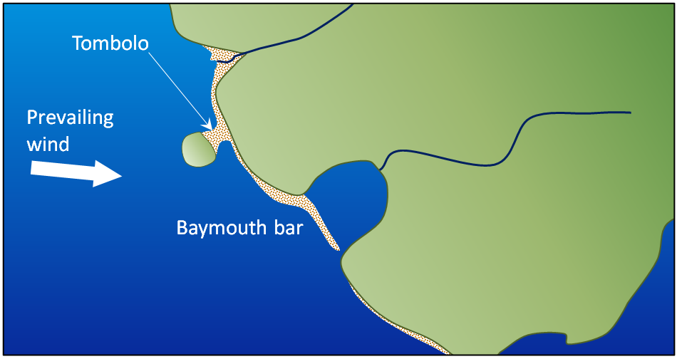
A spit that extends across a bay to the extent of closing, or almost closing it off, is known as a baymouth bar. Most bays have streams flowing into them, and since this water must get out, rarely, a baymouth bar will completely close the entrance to a bay. However, in areas where sufficient sediment is being transported and nearshore islands, a tombolo may form.
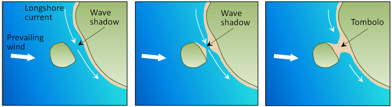
Tombolos are common where islands are abundant, and they typically form where there is a wave shadow behind a nearshore island. This becomes an area with reduced energy, and so the longshore current slows, and sediments accumulate. Eventually, enough sediments accumulate to connect the island to the mainland with a tombolo. (17.3 Landforms of Coastal Deposition – Physical Geology, n.d.)
It is common for barrier islands to form in areas where coastal sediments are abundant and coastal relief is low (because there has been little or no recent coastal uplift). Barrier islands are elongated islands composed of sand that form a few kilometers away from the mainland. They are common along the US Gulf Coast from Texas to Florida and along the US Atlantic Coast from Florida to Massachusetts. North of Boston, the coast becomes rocky, partly because that area has been affected by a post-glacial crustal rebound.
Coasts in tropical regions, between 30 degrees North and South, are carbonate reefs. Reefs form in relatively shallow marine water within a few hundred to a few thousand meters of shore in areas with little or no input of clastic sediments from streams and marine organisms such as corals, algae, and shelled organisms can thrive. The associated biological processes are enhanced where upwelling currents bring chemical nutrients from deeper water, but not so deep that the water is cooler than about 25 degrees Celsius. Sediments that form in the back reef (shore side) and fore reef (ocean side) are typically dominated by carbonate fragments eroded from the reef and from organisms that thrive in the back-reef area protected from wave energy by the reef. (17.3 Landforms of Coastal Deposition – Physical Geology, n.d.)
