Fresh Water Environments
6.2 Streams and River Sytems
Freshwater in streams, ponds, and lakes is an essential part of the hydrologic cycle if only because of its importance to living creatures. Along with wetlands, these freshwater regions contain a tremendous variety of organisms. Streams are bodies of water that consist of constant motion, called a current. Geologists recognize many categories of streams depending on their size, depth, speed, and location. Creeks, brooks, tributaries, bayous, and rivers might all be lumped together as streams. In streams, water always flows downhill, but the form that downhill movement takes varies with rock type, topography, and many other factors.
Streams are the most important agents of erosion and transportation of sediments on Earth’s surface. They are responsible for the creation of much of the topography that we see around us. They are also places of great beauty and tranquility, and of course, they supply much of the water that is essential to our existence. However, streams are not always peaceful and soothing. During large storms and rapid snowmelts, they can become raging torrents capable of moving cars and houses and destroying roads and bridges. When they spill over their banks, they can flood vast areas, devastating populations, and infrastructure. (11 Water – An Introduction to Geology, n.d.)
Parts of a Stream
There are a variety of distinct types of streams. A stream originates at its sources, such as high mountains where snows collect in winter and melt in summer, or a source might be a spring. A stream may have more than one source, and when two streams come together, it is called a confluence. The smaller of the two streams is a tributary of the larger stream. A stream may create a pool where the water slows and becomes more profound.

The point at which a stream comes into a large body of water, like an ocean or a lake, is called the mouth. Where the stream meets the ocean or lake, it is called an estuary. The mix of fresh and saltwater, where a river runs into the ocean, creates a diversity of environments where many different organisms create unique ecosystems.

Stream Erosion and Deposition
Flowing water is a fundamental mechanism for both erosion and deposition. Water flow in a stream is primarily related to the stream’s gradient, but the stream channel’s geometry also controls it. The water flow velocity is decreased by friction along the stream bed, so it is slowest at the bottom and edges and fastest near the surface and in the middle. The velocity below the surface is typically slightly higher than right at the surface because of friction between the water and the air. On a curved section of a stream, flow is fastest on the outside and slowest on the inside.
Other factors that affect stream-water velocity are the size of sediments on the stream bed – because large particles tend to slow the flow more than small ones – and the discharge, or volume of water passing a point in a unit of time. During a flood, the water level always rises, so there is a more cross-sectional area for the water to flow in. However, as long as a river remains confined to its channel, the velocity of the water flow also increases.
Large particles rest on the bottom, bedload, and may only be moved during rapid flows under flood conditions. They can be moved by saltation (bouncing) and by traction (being pushed along by the force of the flow). Smaller particles may rest on the bottom some of the time, where they can be moved by saltation and traction, but they can also be held in suspension in the flowing water, especially at higher velocities. Streams that flow fast tend to be turbulent (flow paths are chaotic, and the water surface appears rough), and the water may be muddy, while those that flow more slowly tend to have laminar flow (straight-line flow and a smooth water surface) and clear water. Turbulent flow is more effective than laminar flow at keeping sediments in suspension. Stream water also has a dissolved load, representing roughly 15 percent of the mass of material transported, and includes ions such as calcium and chloride in solution. The solubility of these ions is not affected by flow velocity.
The faster the water is flowing, the larger the particles that can be kept in suspension and transported within the flowing water. However, as Swedish geographer Filip Hjulström dis-covered in the 1940s, the relationship between grain size and the likelihood of a grain being eroded, transported, or deposited is not as simple as one might imagine. Consider, for example, a 1 mm grain of sand. If it is resting on the bottom, it will remain there until the velocity is high enough to erode it. However, once it is in suspension, that same 1 mm particle will remain in suspension as long as the velocity does not drop below 10 centimeters per second (cm/s.) For a 10 mm gravel grain, the velocity is 105 cm/s to be eroded from the bed but only 80 cm/s to remain in suspension.
On the other hand, a 0.01 mm silt particle only needs a velocity of 0.1 cm/s to remain in suspension but requires 60 cm/s to be eroded. A tiny silt grain requires a higher velocity to be eroded than a grain of sand that is 100 times larger. For clay-sized particles, the discrepancy is even more significant. In a stream, the most easily eroded particles are small sand grains between 0.2 mm and 0.5 mm. Anything smaller or larger requires a higher water velocity to be eroded and entrained in the flow. The main reason for this is that those small particles, especially the tiny grains of clay, have a strong tendency to stick together, so they are challenging to erode from the stream bed.
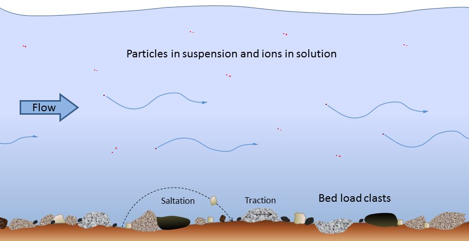
It is essential to be aware that a stream can erode and deposit sediments simultaneously. At 100 cm/s, for example, silt, sand, and medium gravel will be eroded from the stream bed and transported in suspension, coarse gravel will be held in suspension, pebbles will be both transported and deposited, and cobbles and boulders will remain stationary on the stream bed.
A stream typically reaches its highest velocity when it is close to flooding over its banks, known as the bank-full stage. As soon as the flooding stream overtops its banks and occupies the broad area of its flood plain, the water has a much larger area to flow through, and the velocity drops significantly. At this point, sediment that was being carried by the high-velocity water is deposited near the edge of the channel, forming a natural bank or levée. (11 Water – An Introduction to Geology, n.d.)
Stream Types
Stream channels can be straight or curved, deep and slow, or rapid and choked with coarse sediments. The cycle of erosion has some influence on the nature of a stream, but several other factors are essential. Youthful streams that are actively downcutting their channels tend to be relatively straight and are typically ungraded (meaning that rapids and falls are frequent). Youthful streams commonly have a step-pool morphology, meaning that the stream consists of a series of pools connected by rapids and waterfalls. They also have steep gradients and steep and narrow V-shaped valleys, in some cases steep enough to be called canyons.

In mountainous terrains, steep youthful streams typically flow into broad and low-gradient U-shaped glaciated valleys. The youthful streams have high sediment loads, and when they flow into the lower-gradient glacial valleys where the velocity is not high enough to carry all of the sediment, braided patterns develop, characterized by a series of narrow channels separated by gravel bars.

Braided streams can develop anywhere there is more sediment than a stream can transport. One such environment is in volcanic regions, where explosive eruptions produce enormous amounts of unconsolidated material that gets washed into streams. The Coldwater River next to Mt. St. Helens in Washington State is an excellent example.
A stream that occupies a vast, flat flood plain with a low gradient typically carries only sand-sized and finer sediments and develops a sinuous flow pattern. When a stream flows around a corner, the water on the outside has farther to go and tends to flow faster. This leads to erosion of the banks on the outside of the curve, deposition on the inside, and formation of a point bar. Over time, the sinuosity of the stream becomes increasingly exaggerated, and the channel migrates around within its flood plain, forming a meandering pattern.

The meander in the photo below has reached the point where the thin neck of land between two parts of the channel is about to be eroded. When this happens, an oxbow lake will form. Finally, at the point where a stream enters a still body of water, a lake, or the ocean, sediment is deposited and a delta forms.
Rivers
Rivers are the largest types of stream, moving substantial amounts of water from higher to lower elevations. The Amazon River, the planet’s most enormous river, has a flow rate of nearly 220,000 cubic meters per second! People have used rivers since the beginning of civilization as a source of water, food, transportation, defense, power, recreation, and waste disposal.

Divides
A divide is a topographically high area that separates a landscape into different water basins. The rain that falls on the north side of a ridge flows into the northern drainage basin, and rain that falls on the south side flows into the southern drainage basin. On a much grander scale, entire continents have divides, known as continental divides.

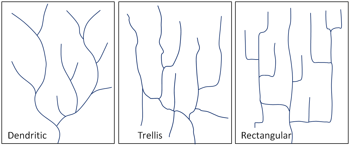
The pattern of tributaries within a drainage basin depends mainly on the type of rock beneath, and on structures within that rock (folds, fractures, faults, etc.). Dendritic patterns, which are by far the most common, develop in areas where the rock (or unconsolidated material) beneath the stream has no particular fabric or structure and can be eroded equally easily in all directions. Examples would be granite, gneiss, volcanic rock, and sedimentary rock that has not been folded. Trellis drainage patterns typically develop where sedimentary rocks have been folded or tilted and then eroded to varying degrees depending on their strength. The Rocky Mountains of B.C. and Alberta are an excellent example of this, and many of the drainage systems within the Rockies have trellis patterns. Rectangular patterns develop in areas with little topography and a system of bedding planes, fractures, or faults that form a rectangular network. The fourth type of drainage pattern, which is not specific to a drainage basin, is known as radial. Radial patterns form around isolated mountains (such as volcanoes) or hills, and the individual streams typically have dendritic drainage patterns. (11 Water – An Introduction to Geology, n.d.)
Over geological time, a stream will erode its drainage basin into a smooth profile. If we compare this with an ungraded stream like Cawston Creek, we can see that graded streams are steepest in their headwaters, and their gradient gradually decreases toward their mouths. Ungraded streams have steep sections at various points, and typically have rapids and waterfalls at numerous locations along their lengths.
The ocean is the ultimate base level, but lakes and other rivers act as base levels for many smaller streams. Engineers can create an artificial base level on a stream by constructing a dam. Sediments accumulate within the flood plain of a stream, and then, if the base level changes, or if there is less sediment to deposit, the stream may cut down through those existing sediments to form terraces.
In the late 19th century, American geologist William Davis proposed that streams and the surrounding terrain develop in a cycle of erosion. Following tectonic uplift, streams erode quickly, developing deep V-shaped valleys that follow relatively straight paths. Gradients are high, and profiles are ungraded. Rapids and waterfalls are common. During the mature stage, streams erode more broad valleys and start to deposit thick sediment layers. Gradients are slowly reduced, and grading increases. In old age, streams are surrounded by rolling hills, and they occupy broad sediment-filled valleys. Meandering patterns are common.
Davis’s work was done long before the idea of plate tectonics, and he was not familiar with the impacts of glacial erosion on streams and their environments. While some parts of his theory are out of date, it is still a useful way to understand streams and their evolution.