
Tectonic Forces
4.7 Tsunamis
Most people never thought much about tsunamis until the cataclysmic event on December 26, 2004, in Indonesia. A tsunami is a Japanese term that means “harbor wave.” There are four significant ways tsunamis form: underwater earthquakes, volcanic eruptions, landslides, or extraterrestrial impacts such as asteroids. These four seismic events will be looked at in greater detail in a minute. The formation of a tsunami by these catastrophic events is called tsunami initiation.
Now once a tsunami is generated, it will travel outward in a circular radius from the tsunami epicenter at 500 mph. However, the height of each wave crest in the deep ocean is only 2-3 feet; thus, large ships never feel tsunamis in the deep ocean. It is essential to stop here and briefly discuss the physics of energy traveling through water. First, a wave of water is called a wave – that was easy! Next, the distance between two wave peaks or heights is called a wavelength. The frequency takes one wavelength (distance between two wave peaks) to pass a given position. Thus, waves with long wavelengths have low frequencies because it takes a long time to cross a given point. Waves that have short wavelengths have high frequencies.
Have you ever watched an object floating in the water as a wave passes by it? Let’s say it is a stick in the ocean. When that wave passes by, the stick does not travel with the wave; rather, the stick bops up and down but stays relatively in the same place. That is because the water does not travel with the wave’s energy; instead, the energy passes through the water causing the water to travel in a circle (which appears as an up, slightly forward, down, and backward motion). The depth of the circular size of motion generated by waves is half the distance from each wave crest. Thus if the distance from one wave crest to the next wave crest is one mile, the depth of the water’s circular motion is half a mile. This is important because tsunamis have very long wavelengths; thus, their depths reach the ocean floor.
It was noted above that the height of a tsunami is only a few feet high, with very long wavelengths out in the deep ocean. This is because in deep water, the amplitude of the waves is minimal, and the wavelengths are pretty large for anyone on a boat to notice. However, as the tsunami approaches the shoreline, it begins to slow down and grow taller because the friction between the oscillating tsunami waves comes into more contact with the rising elevation of the seafloor. This friction causes the wave’s amplitude to grow, the wavelength shortens (distance between each successive tsunami wave), and the frequency becomes shorter, causing the tsunami’s energy to grow taller. The height of a tsunami is called the run-up. Thus when a tsunami reaches the shore, it may have slowed to 30-40 mph but dramatically higher. The size of the run-up is determined by the distance between the tsunami epicenter and the shoreline, the energy released by the tsunami initiation, and the steepness of the continental slope.

Tsunamis are not a massive, single wave coming ashore; instead, they are a series of powerful, rippling waves called a tsunami train. The shoreline frequently disappears as the waves approach shore as the water is pulled back into the ocean to build up the waves. Many people find this strange event enticing and go onto the beach to see the fish flapping on the newly bare ground. However, this is a false sense of security, and within minutes the series of waves come crashing ashore. Often, there can be up to ten individual tsunami waves, and the most powerful waves tend to be the second or third wave. So if the water along the coastline disappears, people need to quickly gather their family and friends and head to higher ground.
Formation of a Tsunami
Earthquakes
Most tsunamis occur because of powerful subduction zone such as the Ring of Fire. Thus, most tsunamis are generated by a reverse fault or thrust fault earthquakes along subduction zones because of the amount of water displaced by these events. However, not all reverse fault earthquakes can initiate tsunamis. The minimum magnitude of an earthquake needed to create a tsunami is a 7.5; a 9.1 magnitude thrust fault generated the Asian tsunami of 2004 along an oceanic-to-oceanic subduction zone. Strike-slip faults along transform boundaries do not create tsunamis because their parallel movement does not displace enough water.
The potential for a tsunami striking the United States is very high for various reasons. One is because of the oceanic-to-continental subduction zone in Washington, Oregon, and northern California. Recall from previous modules that this subduction zone generates earthquakes but has produced the major volcanoes of the region, such as Mount St. Helens, Mt. Rainer, and Mt. Shasta. Research shows that the area experiences a 9.0 magnitude earthquake generating a significant tsunami that would reach coastal cities within 20 minutes every few hundred years. There would be no time to evacuate the people in time.
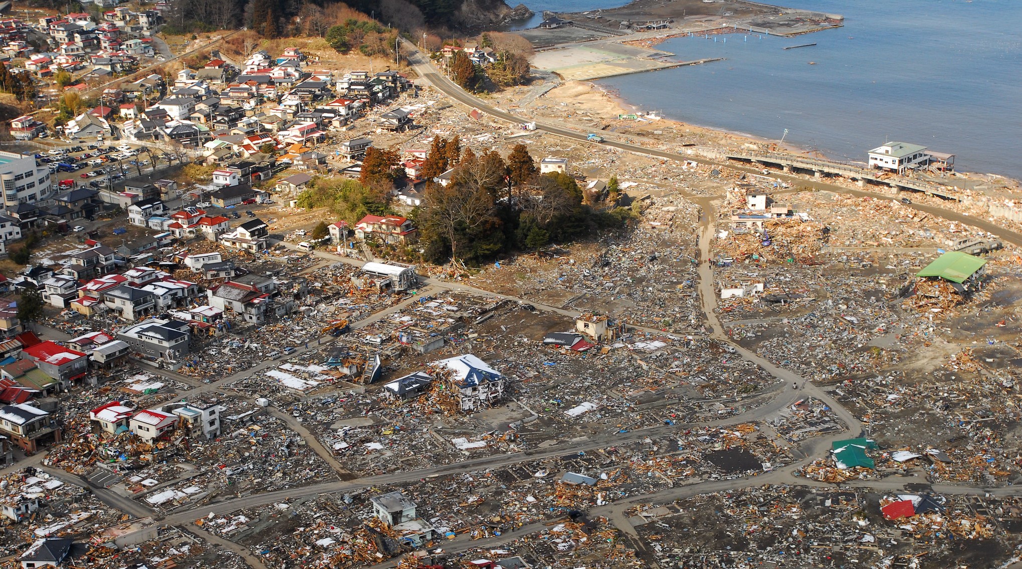
The Great East Japan Earthquake of 2011 was the most documented natural disaster in human history.
Volcanoes
Large, violent, composite volcanoes are less common but still a force to consider. There are a couple of ways a volcano can generate a tsunami. Sometimes just the energy released by the volcano and the pyroclastic flow can initiate a tsunami. Other times, a violent eruption can cause a portion of a volcano’s slope to slide off into the ocean. The most dangerous way would be if a volcano explodes or collapses to generate a caldera in the ocean.
There are some real-world examples of this occurring. For instance, in 1883, on the volcanic island of Krakatau (image on the right), a violent eruption occurred, producing a tsunami that killed 35,000 people and destroyed two-thirds of the island. It is believed a massive pyroclastic flow slammed into the ocean, creating a massive tsunami. Ultimately the eruption was so violent that the island collapsed to produce an enormous caldera of the former island.
Today’s concern is the volcanic islands off western Africa called the Canary Islands. Scientists are concerned with an unstable slope on the west side of one volcanic islands. Their concern is that a significant eruption could cause a portion of the slope to slide off into the Atlantic Ocean, generating a massive tsunami. Within 9 hours – traveling at 500 mph – this tsunami would reach the eastern United States with a run-up of nearly 150 feet!
Last but not least is the major island of Mauna Loa, Hawaii. Scientific studies of the former volcanic islands that used to be over this hot spot show that shield volcanoes grow fastest just before moving off the hot spot. Mauna Loa is the most active volcano globally and is about to move off the hot spot. A new volcanic island is beginning to form underwater just east of the main island. Studies show that the increased activity and lava flows can destabilize portions of the slopes as more weight is added. Fieldworks has discovered that Mauna Loa has had over 60 giant debris avalanches that slide into the Pacific Ocean. These slides tend to be 10-20 miles long and could ultimately generate a tsunami 900 feet high.
Landslides
Large-scale landslides can also displace large amounts of water to generate massive tsunamis. Often, a volcanic eruption or earthquake generates a landslide, which creates a tsunami. One concern for the United States is an underwater landslide – a submarine landslide – off the eastern coast of the continental shelf can displace enough water to generate a 20-foot tsunami and reach the nation within 20 minutes. The most massive landslide ever recorded in human history happened in Lituya Bay, Alaska. A magnitude 7.0 earthquake along the Denali Fault generated a massive rockfall into the bay, which produced a 1,700-foot tsunami. However, the bay contained most of the energy, and thus a major catastrophe was averted. Nevertheless, another such event is occurring in Glacier Bay, Alaska, which is a significant tourist attraction for cruise lines.
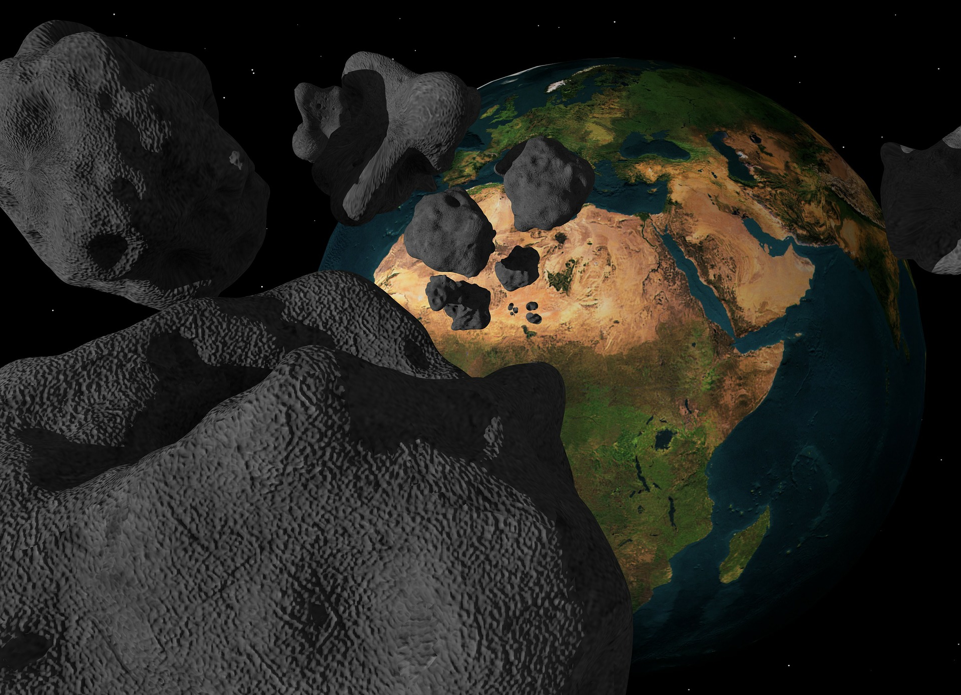
Asteroid Impacts
An asteroid or comet impact would be the rarest but most lethal tsunami. If an asteroid were to make it through the earth’s atmosphere, there is a 70 percent chance it would land in the ocean. For example, an asteroid striking the Atlantic Ocean could produce a tsunami that would cover over half of the nation. All coastal cities around the world would also be destroyed. Furthermore, with 90 percent of all humans living near a large body of water, well, you see the impact! The last asteroid impact in the ocean occurred 65 million years ago and produced a tsunami half a mile high.
Coastal Impacts
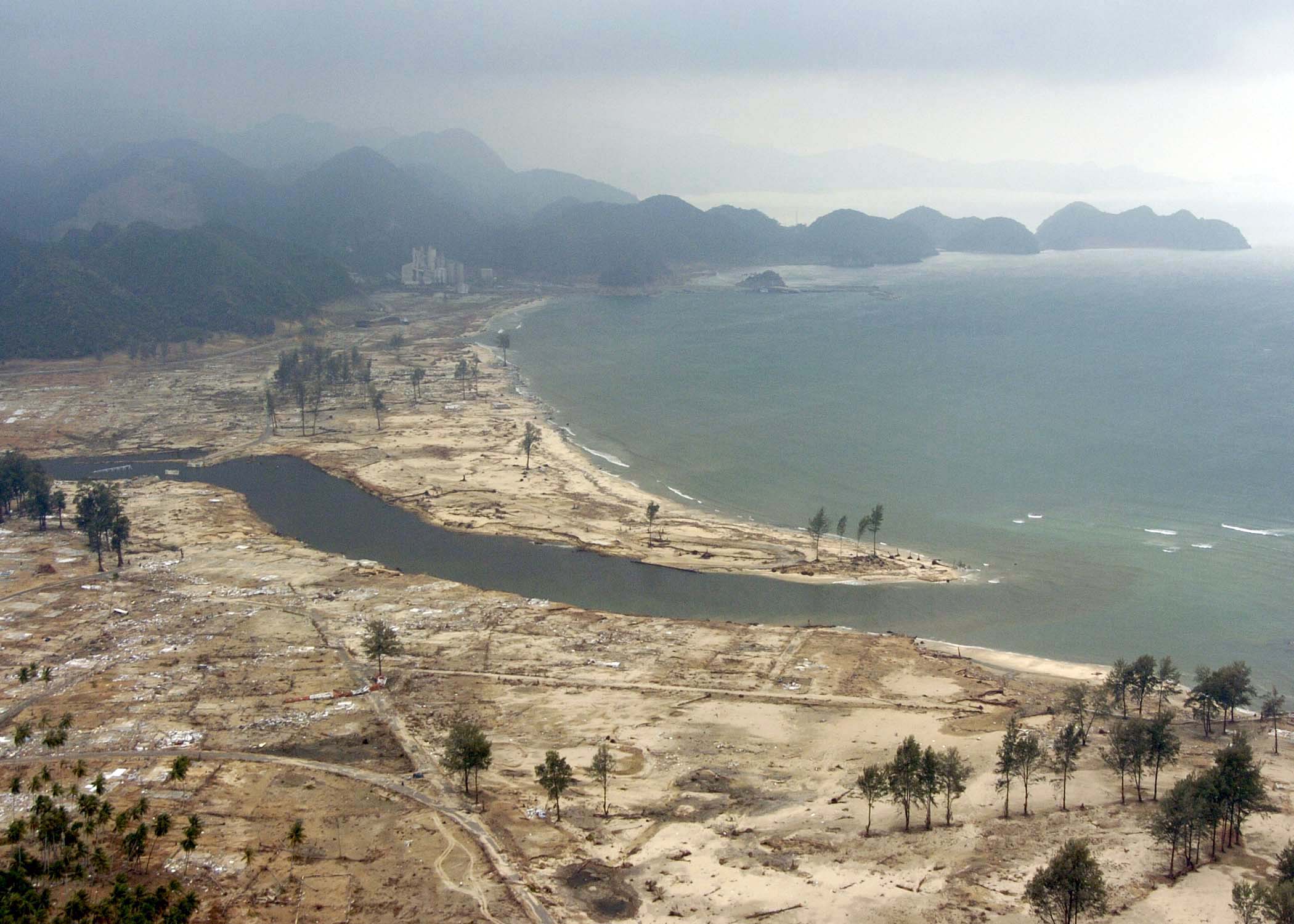
There are a variety of coastal vulnerabilities caused by tsunamis. As noted in previous modules, there are two types of effects of tsunamis (and all disasters). The primary effects are pretty straightforward. Areas at most risk of tsunamis are highly populated coastal regions such as major cities. Moreover, if the tsunami occurs during high tide, the fingers of destruction will reach farther inland. For example, most of the deaths from the Asian tsunami of 2004 were from flooding and debris within the water. Other primary effects include coastal erosion and the destruction of ecosystems. The following are aerial photographs of tsunamis from National Geographic.
The secondary effects of tsunamis are less noticeable. These include contaminated water sources, disease outbreaks, chemical pollution, homelessness, and economic loss. Sometimes the secondary effects are worse than the primary effects because all the new attention occurs with the primary effects. Still, very little attention is on the region after a few months.
Mitigation Against Tsunamis
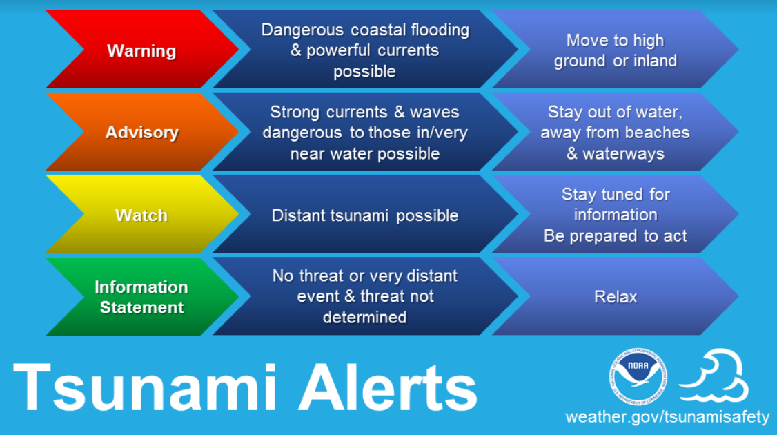
People and ecosystems are pretty resilient to natural disasters, but a lot must be done to prevent massive death and destruction, to begin with. For example, after a deadly tsunami in Hawaii in the 1950s, the United States developed the Pacific Tsunami Warning Center. If a 7.5 magnitude earthquake occurs somewhere in the Ring of Fire, a tsunami watch is released by NOAA, indicating that a seismic event just occurred that could have generated a tsunami. In the Pacific Ocean, a system of instruments on the ocean floor and buoys monitors the Pacific Ocean for tsunamis. If the system detects a tsunami, a signal is sent to satellites, then sent to coastal areas, and a tsunami warning is announced.
Another mitigation measure is tsunami run-up maps. A tsunami run-up map indicates how far a tsunami will travel inland based on the continental shelf and strength of the tsunami. Government agencies can determine proper zoning and building codes by understanding where and how far a tsunami will travel inland. Before the Asian tsunami of 2004, the United States had tsunami run-up maps of Indonesia but were considered classified. Being a more impoverished nation, Indonesia did not have run-up maps. After the catastrophic event, the U.S. military saw how destabilizing this was and decided to release this information from the run-up maps to the region.
Other ways the impacts of tsunamis can be minimized include:
- Strong building codes and zoning policies that local officials enforce
- Planting and protecting existing natural barriers such as vegetation and coastal areas
- Proper education of how to prepare and what to do during and after a tsunami
