
Tectonic Forces
4.1 Geologic Structures and Landforms
Stress and Strain
Stress is the force exerted per unit area, and strain is a material’s response to that force. Strain is deformation caused by stress. Strain in rocks can be represented as a change in rock volume, shape, and fracturing the rock. There are three types of stress: tensional, compressional, and shear. Tensional stress involves pulling something apart in opposite directions, stretching, and thinning the material. Compressional stress involves things coming together and pushing on each other, thickening the material. Shear stress involves transverse movement of the material moving past each other, like a scissor. (9 Crustal Deformation and Earthquakes – An Introduction to Geology, n.d.)
Deformation
The resulting strain can be elastic, ductile, or brittle when rocks are stressed, called deformation. Elastic deformation is the strain that is reversible after the stress is released. For example, when compressing a spring, it elastically returns to its original shape after releasing it. Ductile deformation occurs when enough stress is applied to a material that the changes are permanent, and the material can no longer revert to its original shape. For example, if a spring is stretched too far, it can be permanently bent out of shape. Note that concepts related to ductile deformation apply at the visible (macro) scale, and deformation is more complicated at a microscopic scale. Research of plastic deformation, which touches on the atomic scale, is beyond the scope of introductory texts. The yield point is the strain at which elastic deformation is surpassed, and permanent deformation is measurable. Brittle deformation is when the material undergoes another critical point of no return. When sufficient stress to pass that point occurs, it fails and fractures. (9 Crustal Deformation and Earthquakes – An Introduction to Geology, n.d.)
Important factors that influence how a rock will undergo elastic, ductile, or brittle deformation are the intensity of the applied stress, time, temperature, confining pressure, pore pressure, strain rate, and rock strength. Pore pressure is the pressure exerted by fluids inside the open spaces (pores) inside a rock or sediment. Strain rate is how quickly material is deformed. Rock strength measures how readily a rock will respond to stress. Shale has low strength, and granite has high strength.
Removing heat, such as decreasing temperature, makes the material more rigid. Likewise, heating materials make them more ductile. Heating glass makes it capable of bending and stretching. It is easier to bend a piece of wood slowly without breaking it regarding strain response.
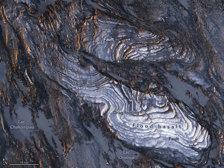
Sedimentary rocks are essential for deciphering the geologic history of a region because they follow specific rules. First, sedimentary rocks are formed with the oldest layers on the bottom and the youngest on top. Second, sediments are deposited horizontally, so sedimentary rock layers are originally horizontal, as are some volcanic rocks, such as ash falls. Finally, sedimentary rock layers that are not horizontal are deformed somehow – often looking like they are tiling into the earth. Scientists can trace the deformation a rock has experienced by seeing how it differs from its original horizontal, oldest-on-bottom position. This deformation produces geologic structures such as folds, joints, and faults caused by stresses.
Stress and Mountain Building
The sheer power and strength of two or more converging continental plates smash upwards creates mountain ranges. Stresses from geologic uplift cause folds, reverse faults, and thrust faults, which allow the crust to rise upwards. The subduction of the oceanic lithosphere at convergent plate boundaries also builds mountain ranges. When tensional stresses pull crust apart, it breaks into blocks that slide up and drop down normal faults. The result is alternating mountains and valleys, known as a basin-and-range.
Folds
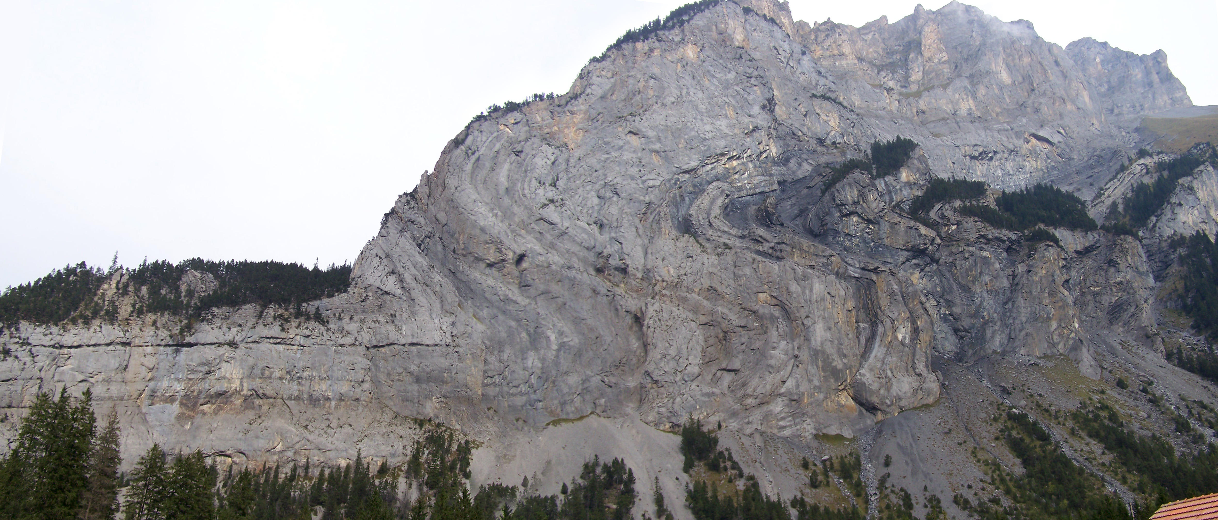
Geologic folds are curved or bent layers of rock by ductile deformation. Terms involved with folds include axis, which is the line along which the bending occurred, and limbs, which are the dipping beds that make up the sides of the folds. Compressional forces commonly form folds at depth, where hotter temperatures and higher confining pressures allow ductile deformation.
Folds are described by the orientation of their axes, axial planes, and limbs. They are made up of two or more dipping beds in opposite directions, which come together along a line called the axis. Each set of dipping beds is known as a fold limb. The plane that splits the fold into two halves is the axial plane. (9 Crustal Deformation and Earthquakes – An Introduction to Geology, n.d.)
Symmetrical folds have mirrored limbs across their axial planes. The limbs of symmetrical folds are inclined at the same but opposite angle, indicating equal compression on both sides of the fold. Asymmetrical folds have dipping, non-vertical axial planes, where limbs dip into the ground at different angles. Recumbent folds are very tight folds with limbs compressed near the axial planes and are generally horizontal, and overturned folds are where the angles on both limbs dip in the same direction. The fold axis is where the axial plane intersects the strata involved in the fold. A horizontal fold has a horizontal fold axis. When the fold axis plunges into the ground, the fold is called a plunging fold.

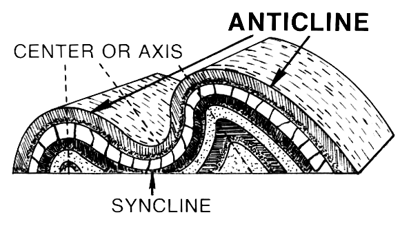
Anticline
Anticlines are arch-like (“A”-shaped) folds, with downward curving limbs that have beds that dip away from the central axis of the fold. They are convex-upward in shape. In anticlines, the oldest rock strata are in the center of the fold along the axis, and the younger beds are on the outside. An antiform has the same shape as an anticline, but the relative ages of the beds in the fold cannot be determined in antiforms. Oil geologists are interested in anticlines because they can form oil traps, where oil migrates up along the limbs of the fold and accumulates in the high point along the axis of the fold. (9 Crustal Deformation and Earthquakes – An Introduction to Geology, n.d.)

Syncline
Synclines are trough-like (“U” shaped), upward-curving folds with beds that dip towards the fold’s central axis. They are concave-upward in shape. In synclines, the older rock is on the outside of the fold, and the youngest rock is on the inside of the fold along the axis. A synform has the shape of a syncline but, like an antiform, does not distinguish between the ages of the units.
Monocline
Monoclines are step-like folds in which flat rocks are upwarped or downwarped, then continue flat. They are relatively common on the Colorado Plateau, where they form “reefs,” ridges that act as topographic barriers and should not be confused with ocean reefs. Capitol Reef National Park is an example of a monocline in Utah. The bending of shallower sedimentary strata can cause monoclines as faults grow below them. These faults are commonly called “blind faults” because they end before reaching the surface and can be normal or reverse faults. (9 Crustal Deformation and Earthquakes – An Introduction to Geology, n.d.)
Dome
A dome is a symmetrical to semi-symmetrical upwarping of rock beds, like in Utah’s San Rafael Swell. Domes have a shape like an inverted bowl, similar to domes on buildings, like the Capitol Building. Some domes are formed from compressional forces, while others are constructed from underlying igneous intrusions, salt diapirs, or impacts like Upheaval Dome in Canyonlands National Park. (9 Crustal Deformation and Earthquakes – An Introduction to Geology, n.d.)
Basin
A basin is the inverse of a dome. The basin is when rock forms a bowl-shaped depression. The Uinta Basin is an example of a basin in Utah. Geologists refer to rocks folded into a bowl shape as structural basins. Sometimes structural basins can also be sedimentary basins in which large quantities of sediment accumulate over time. Sedimentary basins can form due to folding but are more commonly produced in mountain building, between mountain blocks, or via faulting. Regardless of the cause, as the basin sinks, called subsidence, it can accumulate even more sediment as the sediment’s weight causes more subsidence in a positive-feedback loop. There are active sedimentary basins all over the world.
