Tectonic Forces
4.6 Predicting Eruptions and Risk
Predicting Volcanic Eruptions
Volcanologists try to forecast volcanic eruptions, but this has proven as difficult as predicting an earthquake. Many pieces of evidence can mean that a volcano is about to erupt, but the time and magnitude of the eruption are challenging to pin down. This evidence includes the history of previous volcanic activity, earthquakes, slope deformation, and gas emissions. (Volcanic Eruptions | Earth Science, n.d.)
History of Volcanic Activity
A volcano’s history, how long since its last eruption and the period between its previous eruptions, is an excellent first step to predicting eruptions. If the volcano is considered active, it is currently erupting or shows signs of erupting soon. A dormant volcano means no current activity, but it has erupted recently. Finally, an extinct volcano means no activity will probably not erupt again. Active and dormant volcanoes are heavily monitored, especially in populated areas. (Volcanic Eruptions | Earth Science, n.d.)
Earthquakes
Moving magma shakes the ground, so the number and size of earthquakes increase before an eruption. Therefore, a volcano about to erupt may produce a sequence of earthquakes. Scientists use seismographs that record each earthquake’s length and strength to determine if an eruption is imminent.
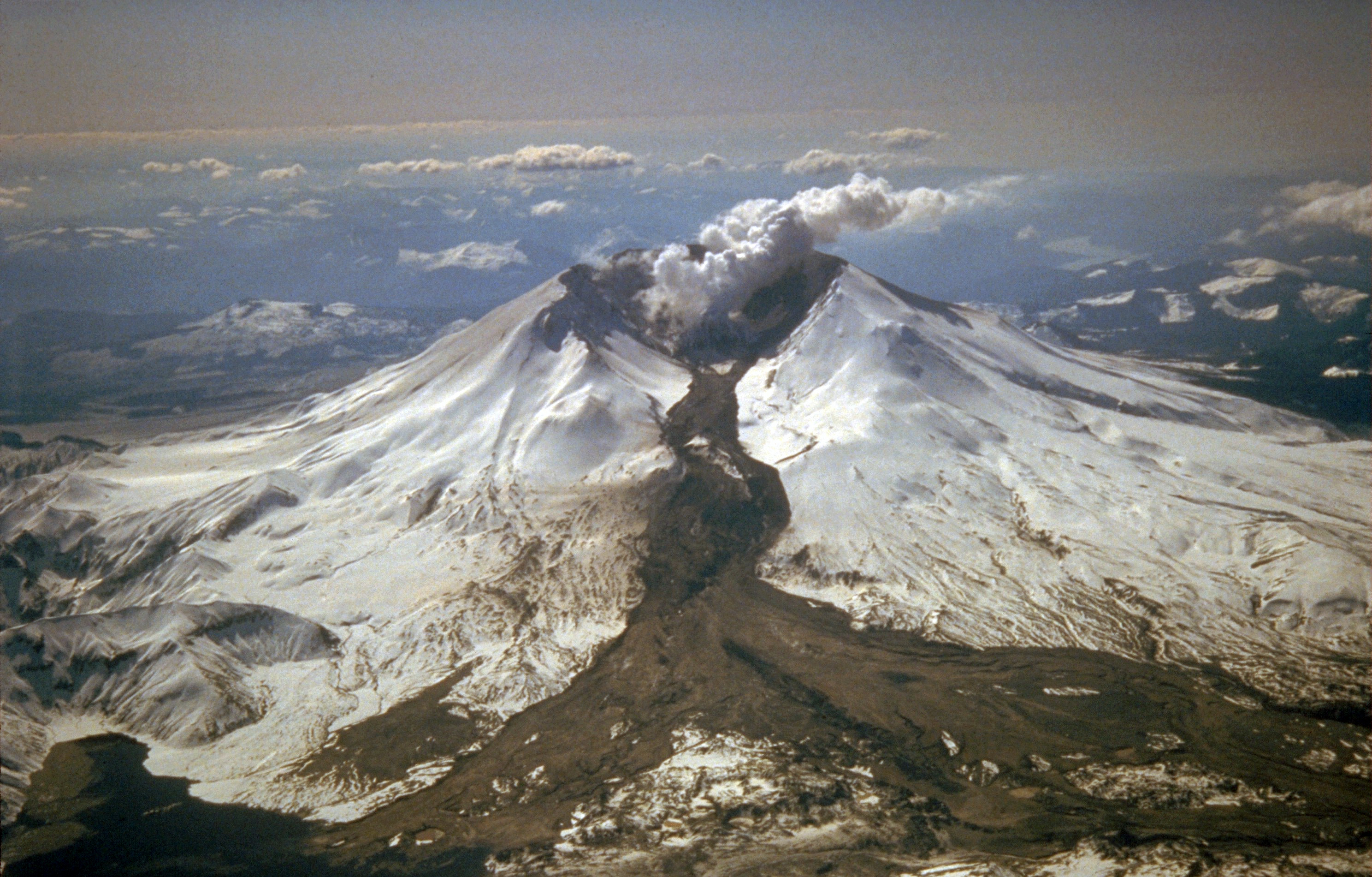
Magma and gas can push the volcano’s slope upward. Most ground deformation is subtle and can only be detected by tiltmeters, which measure the angle of a volcano’s slope. However, ground swelling may sometimes create considerable changes in the shape of a volcano. For example, Mount St. Helens grew a bulge on its north side before its 1980 eruption. Ground swelling may also increase rockfalls and landslides. (Volcanoes | Earth Science, n.d.)
Gas Emissions
Gases may be able to escape a volcano before magma reaches the surface. So scientists measure gas emissions in vents on or around the volcano. Gases, such as sulfur dioxide (SO2), carbon dioxide (CO2), hydrochloric acid (HCl), and even water vapor, can be measured at the site or, in some cases, from a distance using satellites. Then, the amounts of gases and their ratios are calculated to help predict eruptions. (Volcanoes | Earth Science, n.d.)
Remote Monitoring
Some aspects of volcanic monitoring can be monitored using satellite technology. Satellites also monitor temperature readings and deformation. As technology improves, scientists can better detect changes in a volcano accurately and safely. Since volcanologists are usually uncertain about an eruption, officials may not know whether to require evacuation. If people are evacuated, and the eruption does not happen, the people will be displeased and less likely to evacuate the next time there is a threat of an eruption. The costs of disrupting business are high. However, scientists continue to work to improve the accuracy of their predictions.
Volcanic Hazards
Volcanoes are responsible for a large number of deaths. Volcanic hazards have been famous for centuries, but recent eruptions are better documented. The most apparent hazard is the lava itself within a lava flow, but volcanic hazards go far beyond a lava flow. For example, on May 18, 1980, Mount Saint Helens erupted with an explosion and landslide that removed the mountain’s upper 1,300 feet (400 m). This explosion was immediately followed by a lateral blast and pyroclastic flow [23], covering 230 square miles of forest with ash and debris. The effects of the blast are shown on the before and after images. The pyroclastic flow (see below) moved at speeds of 50 – 80 miles per hour (80-130 km/hr), flattened trees, and ejected a giant ash cloud into the air. Watch the 7-minute USGS video for an account of May 18, 1980, which killed 57. Pyroclastic flows are common in explosive eruptions of stratovolcanoes.
In 79 AD, Mount Vesuvius, located near Naples, Italy, violently erupted, sending a pyroclastic flow over the Roman countryside, including the cities of Herculaneum and Pompeii. The buried towns were discovered in an archeological expedition in the 18th century. Pompeii famously contains the remains (casts) of people suffocated by ash and covered by 10 feet (3 m) of ash, pumice lapilli, and collapsed roofs. (4 Igneous Processes and Volcanoes – An Introduction to Geology, n.d.)
Pyroclastic Flows
The most dangerous volcanic hazard are pyroclastic flows. These flows are a mix of lava blocks, pumice, ash, and hot gases between 400 to 1,300 degrees Fahrenheit. The turbulent cloud of ash and gas races down the steep flanks at high speeds up to 120 mph (much faster than people can run) into the valleys around composite volcanoes. Most explosive, silica-rich, high viscosity magma volcanoes such as composite cones usually have pyroclastic flows. The rock tuff and welded tuff are often formed from these pyroclastic flows.
There are numerous examples of deadly pyroclastic flows. In 2014, the Mount Ontake pyroclastic flow in Japan killed 47 people. The flow was caused by magma heating groundwater into steam, rapidly ejected with ash and volcanic bombs. Some were killed by inhaling toxic gases and hot ash, while volcanic bombs struck others. Two short videos below document the eyewitness video of pyroclastic flows. In the early 1990s, Mount Unzen erupted several times with pyroclastic flows. The pyroclastic flow shown in this short video killed 41 people. In 1902, on the Caribbean Island Martinique, Mount Pelee erupted with a violent pyroclastic flow that destroyed the entire town of St. Pierre and killed 28,000 people in moments. (4 Igneous Processes and Volcanoes – An Introduction to Geology, n.d.)

Lahars
A lahar is an Indonesian word for a mudflow mixture of water, ash, rock fragments, and other debris moving down the flanks of a volcano (or other nearby mountains covered with freshly-erupted ash) and entering adjacent river valleys. They form from the rapid melting of snow or glaciers on volcanoes. They are like a slurry of concrete but can flow up to 50 mph while still on the steep flanks. Since lahars are slurry-like, they can travel long distances in river valleys like a flash flood.
During the 1980 Mount St. Helens eruption, lahars reached 17-miles (27 km) down the North Fork of the Toutle River. Prehistoric lahar flows have been mapped at significant volcanoes like Mount Rainier near Tacoma, Washington (Rosi et al. 1999). Prehistoric lahars occupied river floodplains where large cities are found today. A recent scenario played out when a lahar from the volcano Nevado del Ruiz, Colombia, buried a town in 1985 and killed an estimated 25,000 people.
Landslides and Landslide-Generated Tsunamis
The flanks of a volcano are steep and unstable, leading to slope failure and generating dangerous landslides. For example, the landslide at Mount St. Helens in 1980 released a considerable amount of materials as the entire north flank collapsed. The landslide moved at speeds of 100-180 mph. The movement of magma, explosive eruptions, massive earthquakes, and heavy rainfall can trigger these landslides. The landslide material can reach water in unique situations and cause a tsunami. For example, in 1792 in Japan, Mount Unzen erupted, causing a giant landslide that reached the Ariake Sea and made a tsunami that killed 15,000 people on the opposite shore.
Tephra and Ash
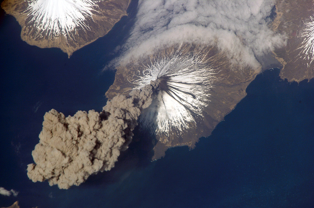
Volcanoes, mainly composite volcanoes, eject substantial amounts of tephra (ejected rock materials) and ash (fragments less than 2 mm or 0.08 inches. Tephra is heavier and falls closer to the vent. Larger blocks and bombs pose hazards to those close to the eruption, such as at the 2014 Mount Ontake disaster in Japan discussed earlier. Ash is fine and can be carried long distances away from the vent, and can cause building collapses and respiratory issues like silicosis. Hot ash can be dangerous to those close to the eruption and disrupt services such as airline transportation farther away. For example, in 2010, the Eyjafjallajökull volcano in Iceland created a giant ash cloud in the upper atmosphere that caused the most significant air travel disruption in northern Europe since a seven-day airline shut down during World War II. No one was hurt, but the cost to the world economy was estimated to be billions of dollars. (4 Igneous Processes and Volcanoes – An Introduction to Geology, n.d.)
Volcanic Gases
Magma contains dissolved gases. As rising magma reaches the surface, the confining pressure decreases, allowing gases to escape, like gases coming out of solution after opening a soda bottle. Therefore, volcanoes, when not erupting, release hazardous gases such as carbon dioxide (CO2), sulfur dioxide (SO2), hydrogen sulfide (H2S), and hydrogen halides (HF, HCl, or HBr). Carbon dioxide can sink and accumulate in low-lying depressions on the earth’s surface. For example, Mammoth Mountain Ski Resort in Mammoth Lakes, California, is located within the Long Valley Caldera. Therefore, the whole ski resort and town are within the caldera. In 2006, three ski patrol members were killed after skiing into snow depressions near fumaroles filled with carbon dioxide (info). Therefore, in volcanic areas where carbon dioxide emissions occur, avoid low-lying areas that trap carbon dioxide.
In rare cases, a volcano can suddenly release gases without warning. Called a limnic eruption, this commonly occurs in crater lakes as gases pour from the water. It infamously occurred in 1986 in Lake Nyos, Cameroon, killing almost 2,000 people due to carbon dioxide asphyxiation.
Volcanic Monitoring
Volcano monitoring requires geologists to use many instruments to detect changes that indicate an imminent eruption. Some of the main observations include regular monitoring for earthquakes (including unique vibrational earthquakes called harmonic tremors, caused by magma movement), changes in the orientation and elevation of the land surface, and an increase in gas emissions.
Volcanic Landforms and Geothermal Activity
Volcanic Landforms and Vents
Volcanoes are associated with many types of landforms. The landforms vary with the composition of the magma that created them. Hot springs and geysers are also surface features related to volcanic activity.
The most apparent landforms created by lava are volcanoes, most commonly as cinder cones, composite volcanoes, and shield volcanoes or eruptions through fissures. The eruptions that made the entire ocean floor are fissure eruptions. Magma intrusions ALSO can create landforms. The image on the right is of Shiprock in New Mexico, the neck of an old volcano that has eroded.
Lava Domes
When lava is viscous, it flows slowly. If there is not enough magma or enough pressure to create an explosive eruption, the magma may form a lava dome. However, the lava does not flow far from the volcanic vent because the magma’s viscosity is so thick. As a result, lava flows often make mounds in the middle of craters at the top of volcanoes.
Lava Plateaus and Land
A lava plateau forms when enormous amounts of fluid lava flow over an extensive area. When the lava solidifies, it creates a large, flat surface of the igneous rock. Lava creates new land as it solidifies on the coast or emerges beneath the water. Over time the eruptions can create whole islands. The Hawaiian Islands are formed from shield volcano eruptions that have grown over the last 5 million years.
Hot Springs and Geysers
Water sometimes encounters the hot rock. The water may emerge at the surface as either a hot spring or a geyser. Water heated below ground that rises through a crack to the surface creates a hot spring. The water in hot springs may reach temperatures in the hundreds of degrees Celsius beneath the surface, although most hot springs are much cooler.
Benefits of Volcanic Activity
There are many benefits to volcanic activity. One of the significant benefits is that volcanic activity can create very fertile soil for agriculture. The problem is that many civilizations developed near volcanoes for this reason – with sometimes deadly effects. Volcanic activity can also generate mineral resources such as gold, silver, nickel, copper, and lead. In addition, volcanic rock is often used for landscaping, tile, and cement.
Some of the most amazing landscapes are near volcanoes because volcanic activity builds land creating, breathtaking scenery. In addition, volcanoes are economically vital for many regions because of their recreational activity and tourism.
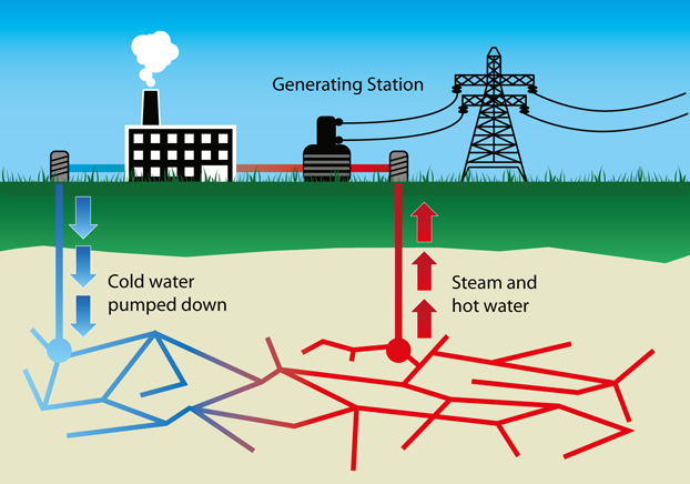
Finally, a new but essential trend is geothermal power. The heat generated by volcanoes can create electricity to power civilization. Geothermal power is an entirely renewable resource free of pollution and energy dependence from fossil fuels. Iceland – the surface manifestation of the mid-Atlantic ridge – aims to power the entire nation on geothermal energy. Geothermal energy is also being used in California, Kilauea, Hawaii, and Utah.