
Weathering, Erosion, and Deposition
5.4 Erosion
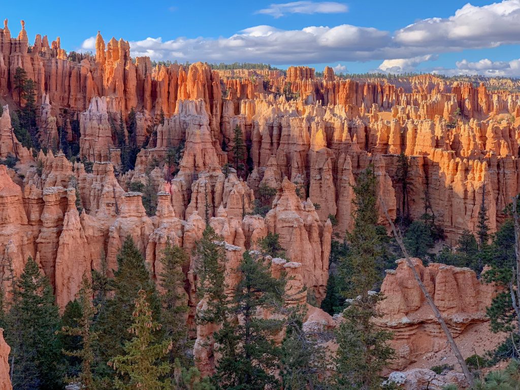
Erosion is a mechanical process, usually driven by water, gravity, wind, or ice that removes sediment from weathering. Liquid water is the principal agent of erosion. Erosion resistance is essential in the creation of distinctive geological features. This is well demonstrated in the cliffs of the Grand Canyon. The cliffs are made of rock left standing after less resistant materials have weathered and eroded. Rocks with different levels of erosion resistance also create unique-looking features called hoodoos in Bryce Canyon National Park and Goblin Valley State Park in Utah.
Erosion by Streams
Streams, any running water from a rivulet to a raging river, complete the hydrologic cycle by returning precipitation that falls on land to the oceans. Some of this water moves over the surface, and some moves through the ground as groundwater. Flowing water does the work of both erosion and deposition.
Flowing streams pick up and transport weathered materials by eroding sediments from their banks. Streams also carry ions and ionic compounds that dissolve easily in the water. Sediments are carried as the following loads: dissolved, suspended, and bed. A dissolved load is composed of ions in solution. These ions are usually carried in the water to the ocean.
Sediments carried as solids as the stream flows are called a suspended load. The stream’s velocity determines the size of particles that can be carried within a load. Faster streams can carry larger particles. Streams that carry larger particles have greater competence. Streams with a steep gradient (slope) have a faster velocity and greater competence.

Particles that are too large to be carried as suspended loads are bumped and pushed along the stream bed, called bed load. Bed load sediments do not move continuously, but rather in intermittent movements, called saltation. Streams with high velocities and steep gradients do a great deal of down-cutting into the stream bed, which is primarily accomplished by movement of particles that make up the bed load.
Stages of Streams
As a stream flows from higher elevations, like in the mountains, towards lower elevations, like the ocean, the work of the stream changes. At a stream’s headwaters, often high in the mountains, gradients are steep. The stream moves fast and does lots of work eroding the stream bed.
As a stream moves into lower areas, the gradient is not as steep. Now the stream does more work eroding the edges of its banks. Many streams develop curves in their channels called meanders. As streams move onto flatter ground, the stream erodes the banks’ outer edges to carve a floodplain, which is a flat-level area surrounding the stream channel.
The base level is where a stream meets a large body of standing water, usually the ocean, but sometimes a lake or pond. Streams work to down cut in their stream beds until they reach base level. The higher the elevation, the further the stream from which it will reach the base level, and the more cutting it has to do.
Stream Deposition
As a stream gets closer to the base level, its gradient lowers, and it deposits more material than it erodes. On flatter ground, streams deposit material on the inside of meanders. A stream’s floodplain is much broader and shallower than the stream’s channel. When a stream flows onto its floodplain, its velocity slows, and it deposits much of its load. These sediments are rich in nutrients and make excellent farmland.
A stream at flood stage carries lots of sediments. When its gradient decreases, the stream overflows its banks and broadens its channel. The decrease in gradient causes the stream to deposit its sediments, the largest first. These large sediments build a higher area around the edges of the stream channel, creating natural levees.

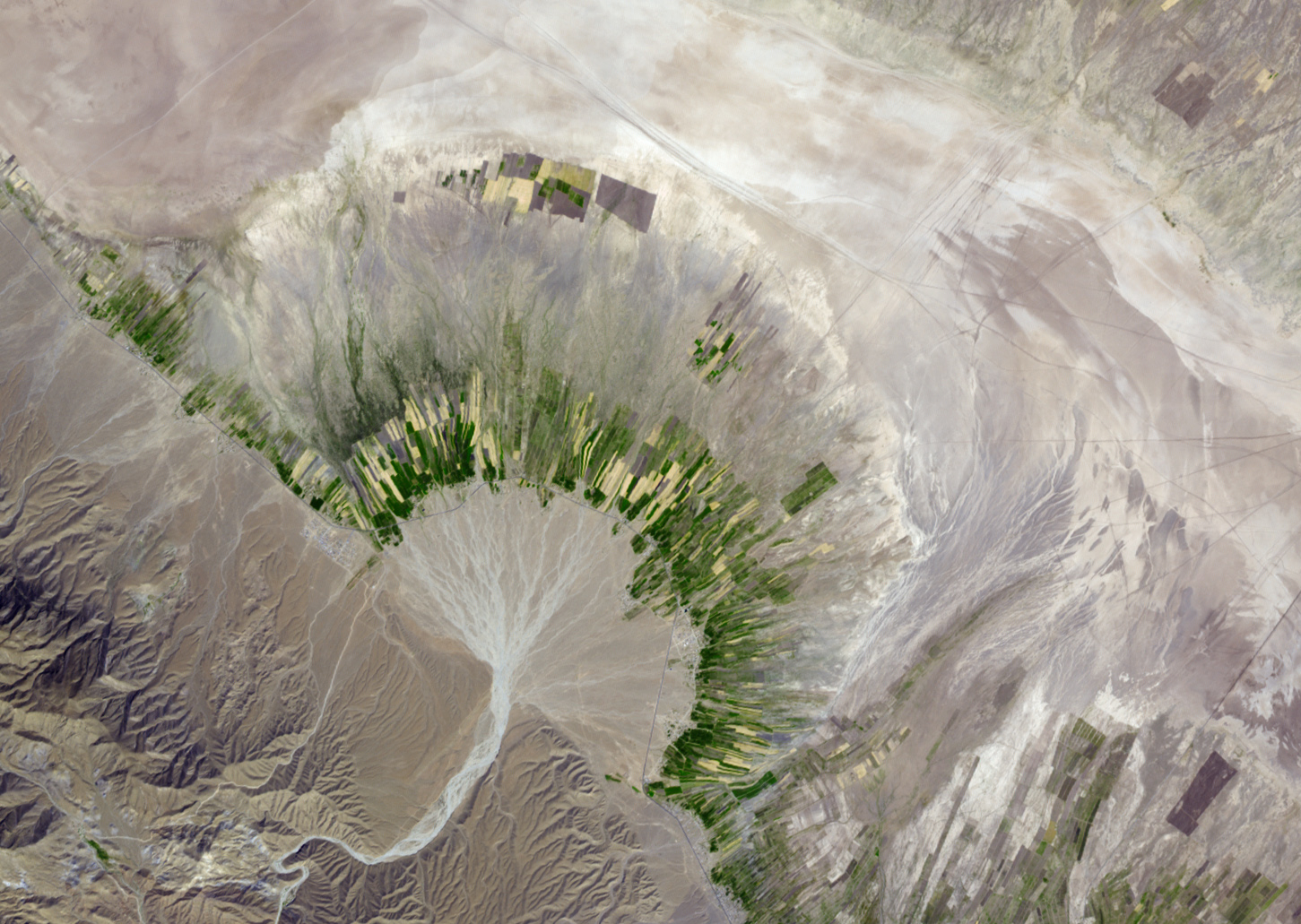
When a river enters standing water, its velocity slows to a stop. The stream moves back and forth across the region and drops its sediments in an extensive triangular-shaped deposit called a delta. If a stream falls down a steep slope onto a broad flat valley, an alluvial fan develops. Alluvial fans generally form in arid regions.

Ground Water Erosion and Deposition
Groundwater is a strong erosional force, as it works to dissolve away solid rock. Carbonic acid is especially good at dissolving the rock limestone. Over many years, groundwater travels along small cracks. The water dissolves and carries away the solid rock, gradually enlarging the cracks, eventually forming a cave. The video below is drone footage of the world’s largest cave, Hang Son Doong, in Vietnam.
Groundwater carries the dissolved minerals in solution. The minerals may then be deposited, for example, as stalagmites (grows from the top) or stalactites (grows from the bottom). If a stalactite and stalagmite join together, they form a column. One wonders of visiting a cave are witnessing the beauty of these fantastic and strangely captivating structures. Caves also produce a beautiful rock, formed from calcium carbonate, travertine. Groundwater saturated with calcium carbonate precipitates as the mineral calcite or aragonite. Mineral springs that produce travertine can be hot, warm, or even cold.
If the roof of a cave collapses, a sinkhole could form. Some sinkholes are large enough to swallow up a home or several homes in a neighborhood.
Wave Action and Erosion
Waves are essential for building up and breaking down shorelines. Waves transport sand onto and off of beaches, transport sand along beaches, carves structures along the shore. The most massive waves form when the wind is powerful, blows steadily for a long time, and blows over a long distance.
The wind could be strong, but if it gusts for just a short time, large waves will not form. Wave energy does the work of erosion at the shore. Waves approach the shore at some angle, so the inshore part of the wave reaches shallow water sooner than the part that is further out. The shallow part of the wave ‘feels’ the bottom first. This slows down the inshore part of the wave and makes the wave ‘bend.’ This bending is called refraction.
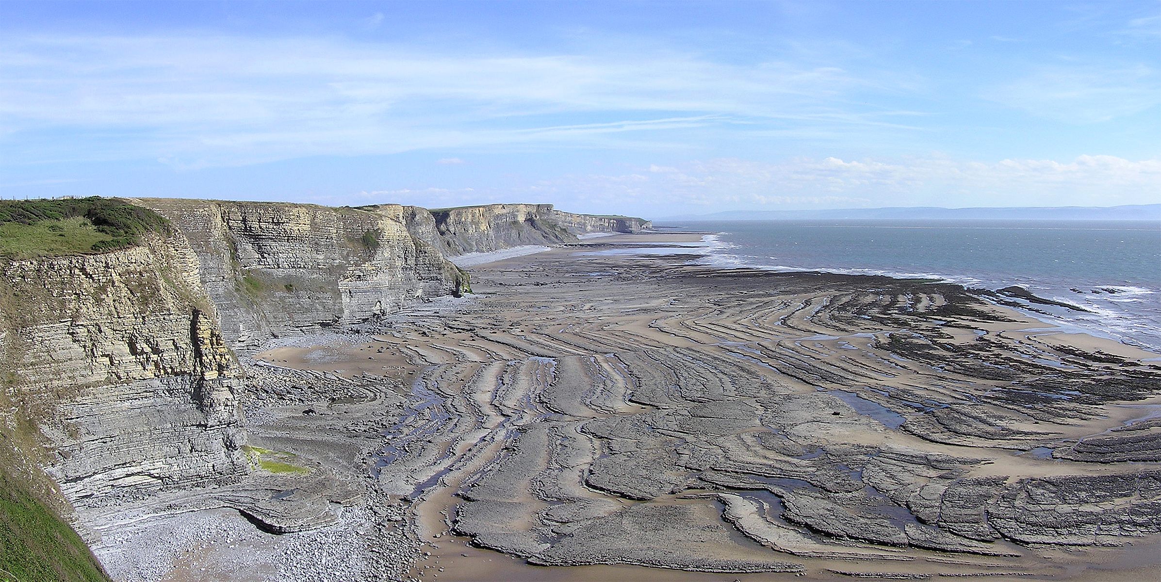
Wave refraction either concentrates wave energy or disperses it. In quiet water areas, such as bays, wave energy is dispersed, so sand is deposited. Areas that stick out into the water are eroded by the intense wave energy that concentrates its power on the wave-cut cliff.
A wave-cut platform is the level area formed by wave erosion as the waves undercut a cliff. An arch is produced when waves erode through a cliff. When a sea arch collapses, the isolated towers of rocks that remain are known as sea stacks.
Wave Deposition
Rivers carry sediments from the land to the sea. If wave action is high, a delta will not form. Waves will spread the sediments along the coastline to create a beach. Waves also erode sediments from cliffs and shorelines and transport them onto beaches.
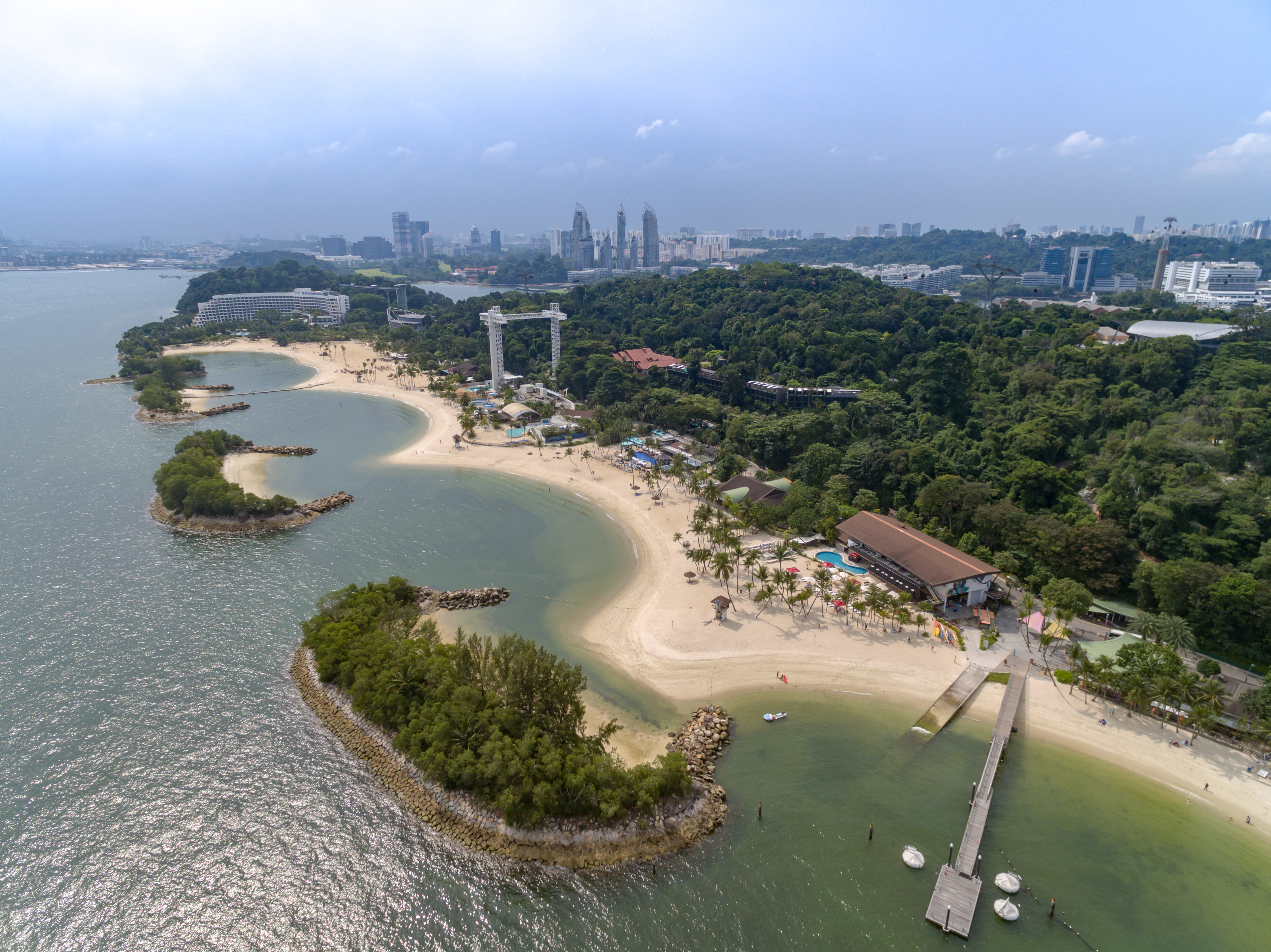
Beaches can be made of mineral grains, like quartz, rock fragments, and also pieces of shell or coral. Waves continually move sand along the shore and move sand from the beaches on shore to bars of sand offshore as the season’s change. In the summer, waves have lower energy, so they bring sand up onto the beach. In the winter, higher energy waves bring the sand back offshore.
Some features form by wave-deposited sand, such as barrier islands and spits. A spit is sand connected to the land and extending into the water. A spit may hook to form a tombolo. Shores that are relatively flat and gently sloping may be lined with long narrow barrier islands. Most barrier islands are a few kilometers wide and tens of kilometers long.
In its natural state, a barrier island acts as the first line of defense against storms such as hurricanes. When barrier islands are urbanized, hurricanes damage houses and businesses rather than vegetated sandy areas in which sand can move. A large hurricane brings massive problems to the urbanized area.
Protecting Shorelines
Intact shore areas protect inland areas from storms that come off the ocean. Where the natural landscape is altered, or the amount of development does damage from a storm too costly to consider, people use several types of structures to attempt to slow down wave erosion. A groin is a long narrow pile of rocks built perpendicular to the shoreline to keep sand at that beach. A breakwater is a structure built in the water parallel to the shore to protect the shore from strong incoming waves. A seawall is also parallel to the shore, but it is built onshore.
People do not always want to choose safe building practices, and instead choose to build a beach house right on the beach. Protecting development from wave erosion is difficult and expensive, and it does not always work. Anti-tsunami seawalls protected the northeastern coast of Japan, yet waves from the 2011 tsunami that resulted from the Tohoku earthquake washed over some seawalls and caused others to collapse. Japan is now planning to build even higher seawalls to prepare for any future (and inevitable) tsunami.
