
Atmosphere and Weather
8.2 Winds and Ocean Currents
Why do temperatures fluctuate around the earth?
Step 1: Go to the ArcGIS Online map, Fluid Earth: Winds and Currents, and explore the map.
Step 2: Click on the four pins, from west to east.
- How many more times will solar rays hit the area between 0-30 degrees than between 60-90 degrees?
- If the earth at the equator is heated more efficiently than other latitudes, what will happen to the air above it?
- Which way will the wind blow to replace the rising air?
Step 3: Click the button, Bookmarks. Select Polar Winds.
- What will happen to the air at the poles if it is cool?
- Which way will air move as it piles up above the poles?
How does the planet work to distribute heat?
Step 4: Click the button, Bookmarks. Select Equatorial Winds.
- What happens to the tropical air after it has risen to the upper atmosphere?
Step 5: Click the Mid-latitude Winds bookmark. Compare them to an average day’s winds at mid-latitudes. Observe that the winds are blowing outward from this latitude.
How are ocean and wind currents tied to each other?
Step 6: With the Details button underlined, click the button, Show Contents of Map (Content).
Step 7: Click the link in the upper-right corner, Modify Map.
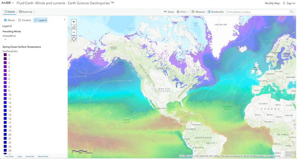
Step 8: Turn on the layer, Spring Ocean Surface Temperature.
- What color are the cold water currents?
Step 9: Add Map Notes to draw in cold ocean currents. Click Add, click Add Map Notes, and then click Create. Next, click Freehand Line to draw each current. Finally, click Change Symbol > Color and choose orange or blue.
Step 10: Add Map Notes to draw in warm ocean currents extending towards the poles.
Step 11: To confirm your drawings, turn on the layer, Ocean Currents.
How does wildlife respond to wind and water currents?
Coldwater currents are usually drawn up from deeper depths when warm surface water is blown away from the continent.
- On which side of a continent do you usually find cold currents?
These deep-water cold currents are rich in nutrients and feed abundant plankton. Fish and birds abound in these areas, but the cold water provides very little evaporation for rainfall on the neighboring continent.
- Which type of land is next to these cold currents worldwide?
What if global winds ceased flowing?
Step 12: The Peruvian Current is a strong cold current. Turn on the layer, Prevailing Winds.
When the prevailing surface winds slow down, a regional climate condition occurs called El Nino. The warm water would spread back across the Pacific, causing much higher rainfalls for western, Central, and South America. Along northern Australia and the surrounding islands, cooler waters remain, so they would normally experience drought.
- The Gulf Stream is a major ocean current moving toward the poles. So if the prevailing winds here slowed, how might this affect the climate of western Europe?
