
Regional and Global Climates and Change
10.3 Climate Change
How can we determine prolonged changes in the environment?
Step 1: Go to the ArcGIS Online map, Climate Change, and explore the map.
Step 2: With the Details button underlined, click the button, Show Contents of Map (Content).
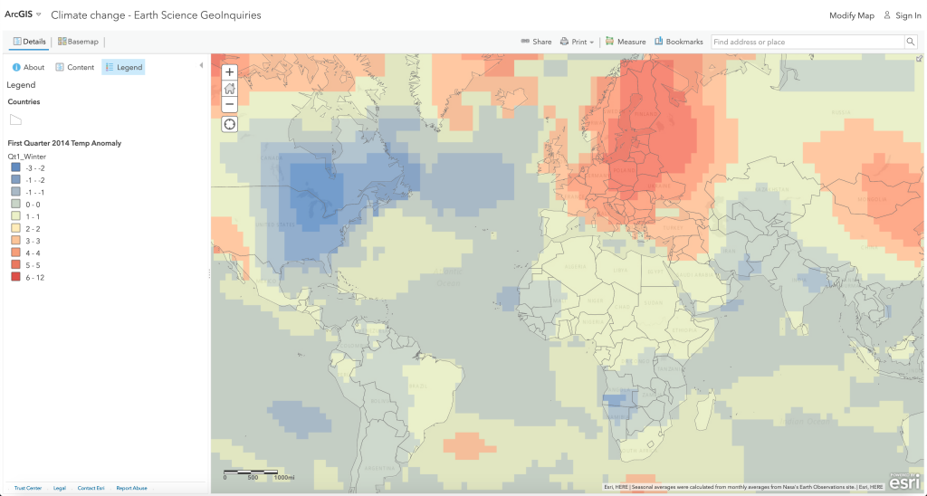
Step 3: Turn on the four seasonal anomaly layers that show how different the temperature was in 2014 from the 30-year average (1950-1980) in Celsius.
Step 4: Click the button, Show Legend.
Note that 2014 was the hottest year on record, even though most central and eastern North America experienced a frigid “polar vortex” winter season.
What is the big deal with a few-degree increase in temperature?
A 3 degree Celsius increase in temperature can make a big difference. The last ice age ended because of a 4 degree Celsius rise in temperature.
- What regions of the planet had the greatest increases in temperature during 2014?
Step 5: Turn off the four seasonal anomaly layers.
Why would some areas of the earth warm more than others?
- The sun is not getting brighter and the sun-to-earth distance has not changed. The extra heat must be coming from the greenhouse gases in the atmosphere absorbing more infrared heat. (T/F)
- Where are the areas farthest above the normal?
- Areas normally covered in snow and ice are experiencing much higher than normal temperatures. This is because the snowfall starts later in the year and melts earlier, allowing the darker earth to absorb more sunlight. (T/F)
How could warmer conditions affect precipitation?
Step 6: Click the button, Bookmarks. Select North America.
Step 7: Turn on the layer, Climate Shifts Koeppen-Geiger.
The data set allows for global, time-based animation of climate patterns from 1900-2100. The default display shows only the last 100 years, using an increment of 5 years.
Step 8: Press the Play button.
- What happens to the dark green, warm temperature zones? (These are wetter, forested areas.)
- What happens to the dry climate zones of the deserts and neighboring grasslands in the U.S.?
- What economic activity do grasslands provide in North America?
Can the concepts of North America be extended to other continents or regions?
- Which countries would appear to be most concerned about losing their grassland food production areas (tan) to desert (brown)?
- Based on the data, do you think the Steppes (prairies) of Asia in southern Russia and Kazakhstan have as much to worry about with grassland loss as the southern Great Plains of North America?
