
1.3 Geospatial Technology
Geospatial technology is one of the primary driving technologies used by geographers to understand the spatial and temporal aspects of the planet. This textbook will focus on geographic information systems (GIS) and have chapters on remote sensing and global positioning systems (GPS). Each of these technologies has its strengths and disadvantages, but they are some of the most powerful tools humans have ever developed.
Geographic Information Systems (GIS)
Suppose you have launched a new business that manufactures solar panels for homeowners. You are planning a mail campaign to bring this revolutionary new product to the attention of prospective buyers. However, since it is a small business, you cannot afford to sponsor coast-to-coast television commercials or send brochures by mail to more than 100 million U.S. households. So, instead, you plan to target the most likely customers – those who are environmentally conscious, have higher than average family incomes, and live in areas with enough sunshine to support solar power.
Fortunately, data is available to help you define your mailing list. For example, household incomes are routinely reported to banks and other financial institutions when families apply for mortgages, loans, and credit cards. In addition, personal tastes related to environmental issues are reflected in behaviors such as magazine subscriptions, credit card purchases, and types of community development. Market research companies collect such data and transform it into information by creating “lifestyle segments” – household categories with similar incomes and tastes. Your solar company can purchase lifestyle segment information by 5-digit or ZIP+4 codes, which designate individual households.
It is astonishing how valuable information is from the millions of daily transactions. The fact that lifestyle information products are often delivered by geographic areas, such as ZIP codes, speaks to the appeal of GIS. The scale of these data and their potential applications are increasing continually with the advent of new mechanisms for sharing information and purchasing linked to our GPS-enabled smartphones. GIS is a computer-based tool to help people transform geographic data into geographic information.
GIS arose from the need to perform spatial queries on geographic data, spatial and non-spatial data that can be imputed into a geodatabase. A spatial query requires knowledge of locations and attributes of that location. For example, an environmental analyst might want to know which public drinking water sources are within one mile of a known toxic chemical spill. Alternatively, a planner might be called upon to identify property parcels in areas subject to flooding.
Defining a Geographic Information System
A geographic information system (GIS) consists of a computer program capable of storing, editing, processing, and presenting geographic data and information as maps from a software perspective. Several GIS software providers, such as Environmental Systems Research Institute Inc. (Esri), distribute the ArcGIS platform. Though companies like Google provide online mapping services and interfaces like Google Earth and Google Maps, such services are not considered fully-fledged GIS platforms. There are also open-source GIS options, such as QGIS, and OpenStreetMap, which are freely distributed and maintained by the open-source community. All GIS software, regardless of vendor, consists of a database management system capable of handling and integrating two types of data: spatial and attribute data.
Spatial data refers to real-world geographic objects of interest, such as streets, buildings, lakes, countries, and locations. In addition to location, each object possesses certain traits of interest or attributes, such as a name, number of stories, depth, or population. GIS software keeps track of the spatial and attribute data and allows us to link the two data types together to create information and facilitate analysis. For example, one way to describe and visualize a GIS is by picturing it as a cake with many layers. Each layer of the cake represents a different geographic theme and geodatabase, such as water features, buildings, and roads, and each layer is stacked on top of another.
As hardware, a GIS consists of a computer, memory, storage devices, scanners, printers, global positioning system (GPS) units, and other physical components. Suppose the computer is situated on a network. In that case, the network can also be considered an integral component of the GIS because it enables us to share data and information that the GIS uses as inputs and creates outputs.
A GIS permits us to maintain, analyze, and share a wealth of data and information as a tool. GIS is used across the public and private sectors, from mapping the path of a hurricane to the more complex task of determining the most efficient U.S. Postal Service routes in a city. Online and mobile mapping, navigation, and location-based services also personalize and democratize GIS by bringing maps and mapping to the masses.
These are just a few definitions of a GIS. Like several geographic concepts discussed previously, no single or universally accepted definition of a GIS exists. There are just as many definitions of GIS as people who use GIS. In this regard, people like you learn, apply, develop, and study GIS in new and compelling ways that unify it.
Three Approaches to GIS
In addition to recognizing the many definitions of a GIS, it is also constructive to identify three general and overlapping approaches to understanding GIS – the application approach, the developer approach, and the scientific approach. Though most GIS users would identify with one direction more than another, they are not mutually exclusive. As GIS and, more generally, information technology advance, the following categories will be transformed and reshaped accordingly.
Application Approach
The application approach to GIS considers a GIS primarily to be a tool. This is also perhaps the most common view of a GIS. From this perspective, a GIS is used to answer questions, support decision-making, maintain geographic data and information inventory, and make maps. As a tool, specific skills should be acquired and required to use and apply a GIS properly. The application approach to a GIS is more concerned with using and applying GIS to solve problems than the GIS itself.
For instance, suppose we want to determine the best location for a new supermarket. What factors are essential behind making this decision? Information about neighborhood demographics, existing supermarkets, the location of suppliers, zoning regulations, and available real estate are all critical to this decision. A GIS platform can integrate information from the census bureau, realtors, the local zoning agency, and even the Internet. A suitability analysis can then be conducted with the GIS, showing the best locations for the supermarket given the various local geographic opportunities (e.g., demographics/consumers) and constraints (e.g., supply chain, zoning, and real estate limitations).
Professional communities and organizations, such as the Urban and Regional Information Systems Association (URISA) and the United States Census Bureau, are concerned with using and applying a GIS.
Developer Approach
Unlike the previous example in which a GIS is applied to answer or solve a particular question, the developer approach to GIS is concerned with developing the GIS as a software or technology platform. Rather than focusing on how a GIS is used and applied, the developer approach is concerned with improving, refining, and extending the tool and technology and is in the realm of computer programmers and software developers.
The ongoing integration and evolution of GIS, maps, the Internet, and web-based mapping can be considered an outcome of the developer approach to GIS. The central challenge is delivering maps, navigation tools, and user-friendly GIS to people via the Internet. The domain of GIS programmers and developers is the underlying logic and computer code that permits us to ask questions about getting from point A to point B on a navigation website or seeing where a new restaurant or open house is located on a web-based map. The Open-Source Geospatial Foundation is another example of a community of GIS developers working to build and distribute open-source GIS software.
The developer approach to GIS drives and introduces innovation and is informed and guided by the application approach’s existing needs and future demands. It is indeed at the forefront; it is dynamic and represents an area for considerable growth in the future.
Scientific Approach – GIScience
The scientific approach to GIS unites with the applications and developer approaches. It is more concerned with broader questions and how geography, cognition, map interpretation, and other geospatial issues, such as accuracy and errors, are relevant to GIS and vice versa. This approach is often referred to as geographic information science (GIScience), and it is also interested in the social consequences and implications of the use and diffusion of GIS technology. From exploring the propagation of error to examining how GIS and related technology are redefining privacy, GIScience is, at the same time, an agent of change and understanding.
Considering the rapid rate of technological and GIS innovation, in conjunction with the widespread application of GIS, new questions about GIS technology and its use are continually emerging. One of the most discussed topics concerns privacy and what is referred to as locational privacy. Location privacy was of little concern to society. However, with the advent of GPS and its integration into cars and other mobile devices, questions, debates, and even lawsuits concerning locational privacy and who has the right to such information are rapidly emerging.
Global Positioning Systems
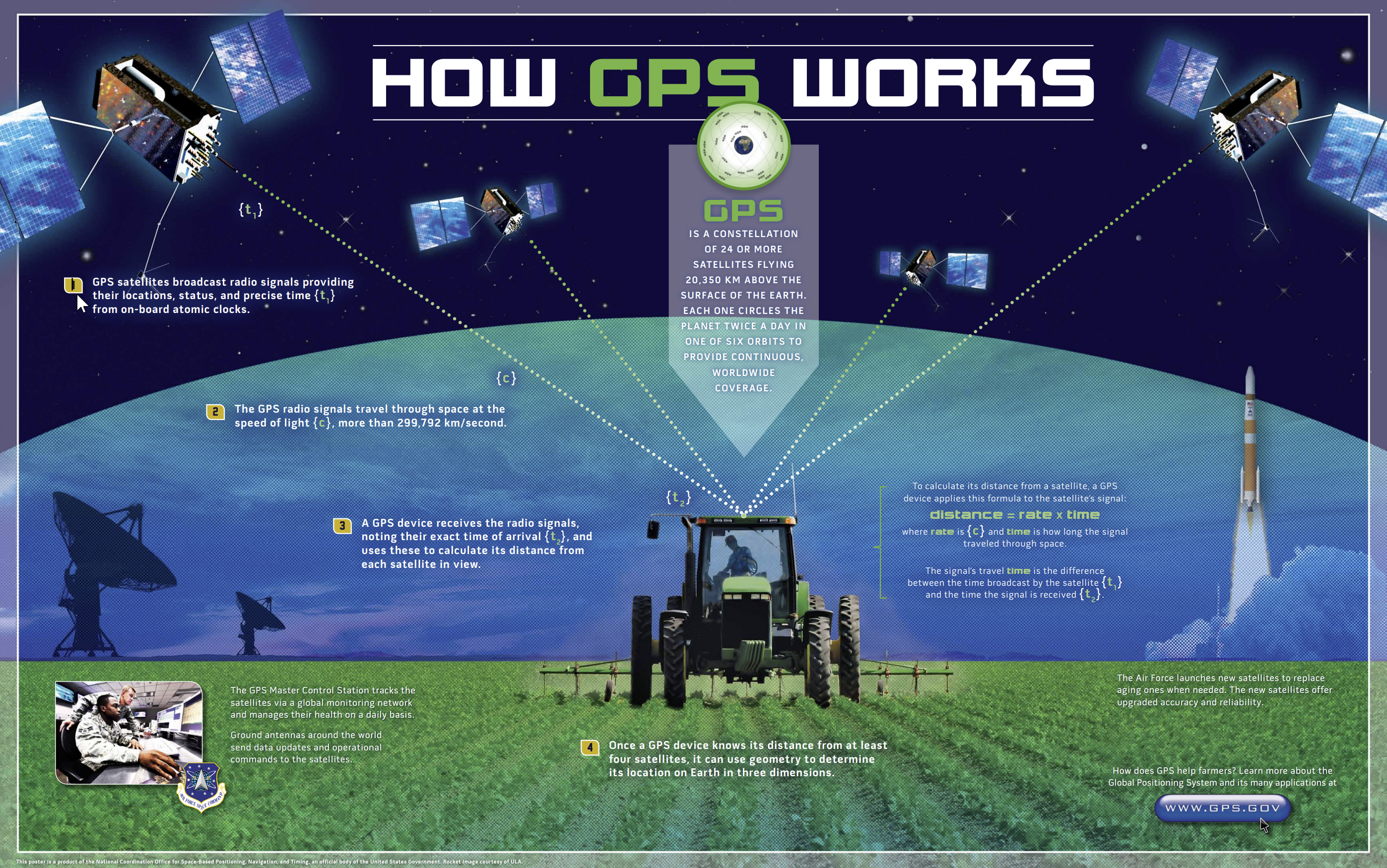
The use of location-based technologies has reached unprecedented levels. Global Positioning Systems (GPS) has been around since the 1980s when the military developed it. It slowly became mainstream with hiking and vehicle devices. However, in the 2010s, GPS has been going through a new revolution with the technology now in smartphones, cameras, microchips for pets, and transportation companies such as Uber and Lyft.
GPS is a satellite-based navigation system made up of a network of twenty-four satellites placed into orbit by the U.S. Department of Defense. GPS was originally intended for military applications, but in the 1980s, the government made the system available for civilian use. GPS works in any weather conditions, anywhere globally, 24 hours a day.
Using GPS to determine your location is not particularly useful if you do not know your landscape. For instance, your GPS could tell you you are in the mall, but you may not know how to get to the door without a map.
Concisely, GPS works like this: satellites circle the Earth twice a day in a very and transmit a signal to Earth. GPS receivers (or smartphones and watches) take this information and use trilateration to calculate the user’s exact location. With distance measurements from a few satellites, the receiver can determine the user’s position and display it on the unit’s electronic map.
Remote Sensing

The distance between the object and observer can be considerable, for example, imaging from the newly launched James Web Space Telescope, or minor, as in microscopes for examining bacterial growth. In geography, remote sensing has a specific connotation with space-borne and aerial imaging systems that remotely sense electromagnetic radiation reflected and emitted from the Earth’s surface.
Remote sensing systems work like a desktop scanner connected to a personal computer. A desktop scanner creates a digital image of a document by recording the intensity of light reflected from the document, pixel by pixel. For example, color scanners may have three light sources and three sets of sensors for visible light’s blue, green, and red wavelengths. Like a desktop scanner’s images, remotely sensed data consists of reflectance values arrayed in rows and columns that make up raster grids.
Remote sensing is used to solve a host of problems across various disciplines. For example, Landsat imagery monitors plant health and foliar changes. In contrast, the imagery produced by IKONOS is used for geospatial intelligence applications (yes, that means spying) and monitoring urban infrastructure. Other satellites, such as AVHRR (Advanced High-Resolution Radiometer), watch the effects of global warming on vegetation patterns worldwide. The MODIS (Moderate Resolution Imaging Spectroradiometer) Terra and Aqua sensors are designed to monitor atmospheric and oceanic composition in addition to the typical terrestrial applications. Today, Unmanned Aerial Systems (UAS), also called drones, extended and mainstreamed aerial imagery collection to the masses.
Click the “Previous” button on the lower left or the ‘Next” button on the lower right to navigate throughout the textbook.
