
1.2 Geographic Science
Most individuals define geography as a field of study that deals with maps, yet this definition is only partially correct. A better description of geography may be the study of natural and human-constructed phenomena relative to a spatial and temporal dimension.
The discipline of geography has multiple intersectionalities that empower our understanding of physical and cultural landscapes. Geography bridges the social sciences with physical sciences and can provide a framework for understanding our world. We can understand the relationships and common factors that tie our human community together by studying geography. The world is undergoing globalization on a massive scale because of the rapid transfer of information and technology. The more we understand our world, the better prepared we will be to address the issues that confront our future. There are many approaches to studying geography. This textbook takes a geospatial approach, focusing on geographic information systems, remote sensing, and global positioning systems.
Geography helps us make sense of the world through four historical traditions:
- Physical geography – the study of the natural features of the Earth’s surface, especially in its current assets, including land formation, climate, currents, and distribution of flora and fauna.
- Human geography: the study of the relationships between the physical environment and the activities of humans.
- World regional geography – the study of specific world regions’ physical and cultural landscapes.
- Spatial analysis – the study of the physical and cultural environments using various geospatial technologies, including geographic information systems (GIS), global positioning systems (GPS), and remote sensing such as satellite and aerial imagery.
The discipline of geography has a history that stretches over many centuries. Over this period, geography has become a basic form of human scholarship. Examining the historical evolution of geography as a discipline provides some essential insights concerning its character and methodology. These insights are also helpful in gaining a better understanding of the nature of physical geography.
Geographers seek to answer the where, why, and how. For example, knowing a country’s location is undoubtedly helpful, but geographers dig deeper by asking:
- Why is it located there?
- Why does it have a particular shape or spatial pattern, and how does this affect how it interacts with the surrounding area?
- Why do the people of the country have certain cultural features?
- Why does the country have a specific style of government?
- How do we analyze the spatial and temporal patterns in human-environment interactions?
The term “geography” comes from the Greek term geo, meaning “the earth,” and graphia, meaning “to write,” and many early geographers did precisely that: they wrote about the world. Ibn Battuta, for example, was a scholar from Morocco who traveled extensively across Africa and Asia in the 14th century C.E. Eratosthenes is commonly considered the “Father of Geography,” and he authored the book on the subject in the third century BCE. His three-volume text, Geographica, included maps of the world, including different climate zones, the locations of hundreds of other cities, and a coordinate system. This was a revolutionary and highly regarded text, especially for the time. Eratosthenes is also credited as the first person to calculate the circumference of the Earth. Many early geographers, like Eratosthenes, were primarily cartographers, referring to people who scientifically studied and created maps, and early maps, such as those used in Babylon, Polynesia, and the Arabian Peninsula, were often used for navigation. In the Middle Ages, as academic inquiry in Europe declined with the fall of the Roman Empire, Muslim geographer Muhammad al-Idrisi created one of the most advanced maps of pre-modern times, inspiring future geographers from the region.
Though using more advanced tools and techniques, geography today draws on the foundations laid by these predecessors. Attention to the spatial and temporal perspective unites all geographers. As geographer Harm deBlij once explained, there are three main ways to look at the world. One way is chronological, as a historian might examine the sequence of world events. A second way is systematical, as a sociologist might explore the societal systems that help shape a given country’s structures of inequality. The third way is spatially, and this is the geographic perspective. When confronted with a global problem, geographers immediately ask where and why.
Spatial and Temporal Thinking
Although geography is a broad discipline that includes quantitative techniques like statistics and qualitative methods like interviews, all geographers share this common way of looking at the world from a spatial and temporal perspective. Geographers can better analyze the world spatially and over time as geospatial technology advances. For example, the Landsat satellites repeated going over a particular location on Earth roughly every 16 days for the past 50 years, starting in 1972. So this allows us to understand the world spatially and over time (temporally).
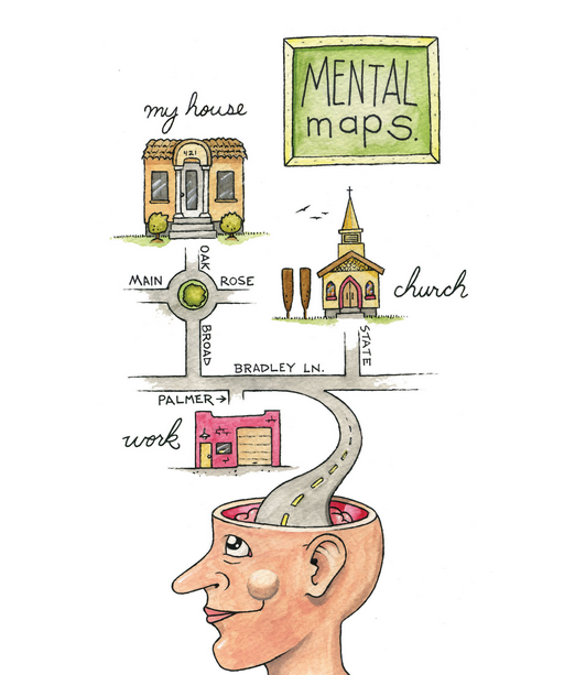
At no other time in the history of the world has it been easier to create or acquire a map of anything? Maps and geospatial technology are literally and virtually everywhere. Though the modes and means of making and distributing maps have been revolutionized with recent advances in computing like the Internet, the art and science of map-making date back centuries. This is because humans are inherently spatial organisms, and for us to live in the world, we must somehow relate to it. Enter the mental map.
Mental Maps
Mental or cognitive maps are psychological tools that we all use every day. As the name suggests, mental maps are maps of our environment stored in our brains. We rely on our mental maps to get from one place to another, plan our daily activities, or understand and situate events we hear about from our friends, family, or news. Mental maps also reflect the amount and extent of our geographic and spatial awareness of our local and global environment. What you choose to include and exclude on your map provides insights into what places you think are important and how you move through your residence.
What you include and omit on your map, by choice, speaks volumes about your geographical knowledge and spatial awareness, or lack thereof. Recognizing and identifying what we do not know is essential for learning. Only when we place the unknown can we ask questions, collect information to answer those questions, develop knowledge through answers, and begin understanding the world where we live.
Asking Spatial and Temporal Questions
Filling in our mental maps and, more generally, the gap in our geographic knowledge requires us to ask questions about the world where we live and how we relate to it. Such questions can be simple with a local focus or more complex with a global perspective. The thread that unifies such questions is geography. For instance, where is an essential part of the questions “Where is the nearest hospital?” and “Where are the biodiversity hotspots concerning cities?” Articulating questions clearly and breaking them into manageable pieces are valuable skills when using and applying geospatial technology.
Spatial and temporal questions, called geographic literacy, can help us identify complex issues and solve difficult problems to understand better and improve our environment. These geographic questions are listed here and followed by a few examples (Nyerges, 1991). Nyerges, T. 1991. “Analytical Map Use.” Cartography and Geographic Information Systems (formerly The American Cartographer) 18: 11–22.
Questions about geographic location:
- Where is it?
- Why is it here or there?
- How much of it is here or there?
Questions about geographic distribution:
- Is it distributed locally or globally?
- Is it spatially clustered or dispersed?
- Where are the boundaries?
Questions about the geographic association:
- What else is near it?
- What else occurs with it?
- What is absent in its presence?
Questions about geographic interaction:
- Is it linked to something else?
- What is the nature of this association?
- How much interaction occurs between the locations?
Questions about geographic change:
- Has it always been here?
- How has it changed over time and space?
- What causes its diffusion or contraction?
People from various areas of expertise, industries, and professions frequently ask these and related geographic questions. For instance, urban planners, traffic engineers, and demographers may be interested in understanding the commuting patterns between cities and suburbs (geographic interaction). Biologists and botanists may wonder why one animal or plant species flourish in one place, not another (geographic location/distribution). Epidemiologists and public health officials are interested in where disease outbreaks occur and how, why, and where they spread (geographic change/interaction/location).
Geospatial technology can assist in answering all these questions and many more. Furthermore, a GIS often opens additional avenues of inquiry when searching for answers to geographic questions. Herein is one of the greatest strengths of the GIS. While a GIS can answer specific questions or solve problems, it often unearths even more exciting questions. It presents more problems to be solved in the future.
Click the “Previous” button on the lower left or the ‘Next” button on the lower right to navigate throughout the textbook.
